

Water Quality Standards
Revision, West Division Main
Canal near Hermiston, Oregon
Submitted to: US Enviornmental Protection Agency
Report

June 2012
Last Updated: 02/17/2012
By: Don Butcher
11-WQ-034
This report prepared by:
Don Butcher and Debra Sturdevant
Oregon Department of Environmental Quality
811 SW 6th Avenue
Portland, OR 97204
1-800-452-4011
Contact: Don Butcher
(541) 278-4603
or
Debra Sturdevant
(503) 229-6691
Table of Contents
EXECUTIVE SUMMARY.....................................................................................................................................................................ii
1 INTRODUCTION 1
2 BACKGROUND 2
2.1 CANAL DESCRIPTION 2
2.2 CANAL HISTORY 13
2.3 CANAL USES AND MANAGEMENT 14
2.4 POLICY BACKGROUND 17
2.4.1 Standards Revision 17
2.4.2 Related Policy 20
2.5 AUTHORITIES 20
3 REVISION OF DESIGNATED USES FOR CANAL 21
3.1 GEOGRAPHIC SCOPE OF STANDARDS REVISION 21
3.2 HISTORICALLY DESIGNATED BENEFICIAL USES 21
3.3 EXISTING USES 22
3.4 HISTORICALLY DESIGNATED BENEFICIAL USES THAT ARE NOT EXISTING USES 25
3.5 ATTAINABLE USES 27
3.6 PROPOSED REVISION OF BENEFICIAL USES 28
3.6.1 Public and Private Domestic Water Supply 29
3.6.2 Fish and Aquatic Life 29
3.6.3 Fishing 30
3.6.4 Boating 30
3.7 INFLUENCE ON DOWNSTREAM WATERS 31
4 PROPOSED CRITERIA REVISIONS 32
4.1 PROPOSED CRITERIA 32
4.2 BASIS FOR PROPOSED CRITERIA 33
4.2.1 Numeric Criteria 35
4.2.2 Changes to public comment proposal. 36
4.2.3 Narrative Criteria 40
4.2.4 Other States 42
5 TEXT OF PROPOSED RULE CHANGE 43
6 PUBLIC & STAKEHOLDER PARTICIPATION 47
7 REFERENCES 49
8 APPENDICES 51
8.1 CITY OF HERMISTON WASTE WATER TREATMENT PLANT AND PLANNING 51
8.2 CODE OF FEDERAL REGULATIONS 130.10, TITLE 40 53
8.3 FISH SCREEN CORRESPONDENCE, OREGON DEPARTMENT OF FISH AND WILDLIFE TO DEQ 55
Executive Summary
The Oregon Department of Environmental Quality is revising water quality standards for the West Division Main Canal, a constructed irrigation canal near Hermiston, Oregon. Over the years, as DEQ developed water quality standards across the state, beneficial use designations were over-generalized in some instances. DEQ is revising water quality standards that apply to the West Division Main Canal to reflect the ways the canal is actually used. The impetus for this action is a request by the city of Hermiston to discharge highly-treated municipal wastewater to the canal during the irrigation season, where it would mix with canal water and then be reused for irrigation. The city indicated that the state’s designated beneficial uses for the canal are incorrect, and that revising the standards to designate a more appropriate list of uses would make discharge to the canal a viable option for re-use of the city’s wastewater. After evaluating the canal, DEQ agreed that it was never intended or suitable for some of the broadly designated uses, such as drinking water and fishing.
Under the city’s current National Pollutant Discharge Elimination System permit, it may discharge effluent to the Umatilla River year round, or apply the treated effluent directly to crops (land application) during the irrigation season. The city’s proposed discharge to the canal, which includes upgrading the treatment technology, would also require an NPDES permit, which would provide for discharge to the river and the canal depending on the season. During parts of the spring, summer and fall, the Umatilla River does not meet the water quality standard for temperature and various other water quality indicators. Decreased pollution is a high priority for Umatilla Basin watershed restoration efforts. Discharging the city’s wastewater to the canal rather than the river during the irrigation season would support progress towards this priority.
Federal regulations require that, at a minimum, existing beneficial uses of waterbodies be protected. As such, when removing or revising designated uses, DEQ must ensure that existing uses continue to be protected in addition to assuring that water quality standards include criteria sufficient to support the revised uses. The federal regulations also require a use attainability analysis when any of the uses specified in Section 101(a)(2) of the Clean Water Act are removed or revised in a manner leading to less stringent criteria. The uses identified in this CWA section are described as those that provide “for protection and propagation of fish, shellfish, and wildlife and recreation in and on the water." DEQ proposes to remove and revise certain Section 101(a)(2) uses for the West Division Main Canal and therefore this document serves as a use attainability analysis. Existing uses (those attained on or after Nov. 28, 1975) are not being removed. This action corrects uses that DEQ designated for the canal as part of its broad designations for all waters of the Umatilla subbasin. In addition, as described in further detail in this document, most of the waterbody is man-made and was never a natural stream.
The current designated beneficial uses for the West Division Main Canal are:
• Public domestic water supply
• Private domestic water supply
• Industrial water supply irrigation
• Livestock watering
• Fish and aquatic life (Redband trout)
• Wildlife and hunting
• Fishing
• Boating
• Water contact recreation
• Aesthetic quality and
• Hydropower
DEQ proposes to remove the following designated uses from the West Division Main Canal: public domestic water supply, private domestic water supply, fish and aquatic life, fishing, and boating. In addition, DEQ proposes to replace the general fish and aquatic life use designation and the Redband trout subcategory with a subcategory of “modified aquatic habitat” use for the overflow channels segment of the canal, which connects the constructed channel to the Columbia River.
Based on DEQ’s evaluation of the attainable uses for the West Division Main Canal and its subsequent proposed revisions to the designated uses, DEQ has identified irrigation, livestock watering, and water contact recreation as the highest attainable beneficial uses. In addition to the proposed revisions to the designated uses, DEQ proposes to adopt numeric criteria recommended by the US Environmental Protection Agency to protect the revised uses of the canal. To augment the numeric criteria and to address situations that may arise regarding pollutants for which numeric criteria do not exist, DEQ is also proposing narrative criteria for the canal.
1
2 Introduction
DEQ proposes to revise water quality standards for the West Division Main Canal located near Hermiston, Oregon. This action corrects the prior beneficial use designations for the canal and establishes criteria that protect the revised uses. To this end, this document describes the canal, its operation and setting, and the timing and volume of canal inputs and return flow. The document also describes DEQ’s analysis of the current designated beneficial uses, the extent to which those uses are existing or attainable, and DEQ’s proposed revisions to beneficial uses based on that analysis. Existing uses must be protected and are defined as "... those uses actually attained in the waterbody on or after Nov. 28, 1975, whether or not they are included in the water quality standards" [Title 40 Code of Federal Regulations 131.3(e)]. Finally, the document identifies the water quality criteria that DEQ proposes to protect the revised uses of the canal, and the supporting information for those criteria.
The West Division Main Canal is a relatively large constructed irrigation canal near Hermiston, Oregon. Built in 1916, it carries water westward from the Umatilla and Columbia Rivers to area farms, with its terminus west of the city of Boardman. Because Oregon designated beneficial uses broadly for water quality standards (i.e. all waters of the Umatilla Subbasin), uses such as public and private domestic drinking water supply and fishing were designated for the canal as well as agricultural uses. In fact, the existing uses of the canal are more limited, with the primary uses being irrigation and to a lesser extent, livestock watering. DEQ considers the current standards to be inappropriate for the nature and purpose of the canal.
For the purpose of changing the designated uses and associated water quality criteria, the information in this document serves as the use attainability analysis required by federal regulation. Under state and federal law, Oregon water quality standards are adopted as administrative rules by Oregon's Environmental Quality Commission and require approval by the EPA to become effective under the CWA. This document provides the basis for the proposed rules revisions changing the uses and associated criteria for the West Division Main Canal. It is the core part of a rule-making package to establish revised standards for the canal.
The city of Hermiston wastewater treatment plant, which has a National Pollutant Discharge Elimination System permit allowing it to discharge to the Umatilla River, has requested to discharge highly treated effluent to the West Division Main Canal where it can be re-used for irrigation. The city prefers this alternative to that of discharging to the Umatilla River during the irrigation season, when it is challenging for the treatment plant to meet effluent limits for temperature due to low flow in the River. The Umatilla River is designated for various aquatic life uses, including salmonid rearing, which is temperature-sensitive. Potential impacts to these uses associated with the city's effluent will be eliminated if the city is able to remove its discharge from the river. Another alternative considered by the city, that it currently utilized on an intermittent basis, has been direct land application of its effluent. Although this approach has been implemented in the past, the city prefers canal discharge instead, citing practical reasons. The city’s planned discharge to the West Division Main Canal would be facilitated by DEQ's designating accurate beneficial uses and appropriate water quality criteria for the canal. Appendix 8.1 contains further information regarding the city of Hermiston's wastewater planning. Please note that the selection of city wastewater outfall location(s) and treatment scenarios, and the permitting process, are separate from this standards revision. Treatment plant information and alternatives are only discussed to provide context.
DEQ proposes to remove public domestic water supply, private domestic water supply, fish and aquatic life, fishing and boating as designated uses of the West Division Main Canal. DEQ proposes to replace the general “fish and aquatic life” use designation and Redband trout use subcategory for the overflow channels segment of the canal with an aquatic life subcategory of “modified aquatic habitat." The modified aquatic habitat subcategory more accurately represents the existing and attainable aquatic life use for the overflow channels segment of the canal. None of the uses proposed for removal are existing uses, meaning that these activities have not occurred or been supported within the canal since at least Nov. 28, 1975. The designated beneficial uses DEQ proposes to retain include the following existing uses of the canal: irrigation, livestock watering, wildlife and hunting (as an aggregate category, but hunting does not occur), and aesthetic quality. Limited water contact by humans occurs as well and DEQ does not propose to revise the current water contact recreation use designation at this time. In addition, the feasibly attainable designated uses of industrial water supply and hydropower will be retained, although their likelihood of occurrence is remote.
3 Background
3.1 Canal Description
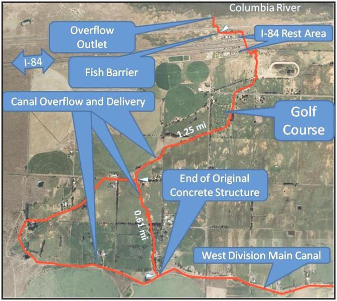
The West Division Main Canal is located near the cities of Hermiston and Boardman near Oregon's northern border (Figure 1). The head of the canal diverts water at Three-Mile Falls Dam (Figure 2) on the Umatilla River. From there, the constructed, concrete-lined part of the canal extends 27 miles, predominantly westward to approximately four miles southwest of Boardman, Oregon (Figure 3). Canal overflow then exits the main concrete structure and flows northward via two overflow channels that reconnect at a point roughly one mile southwest of the I-84 Boardman Rest Area. This single overflow channel then continues to the Rest Area and then north to the Columbia River (Figure 4). The entire canal is approximately 29 miles in length. Unlike the main concrete structure, which traverses hill slopes, parts of the overflow channels follow historic swales. While most of the overflow channels segment is un-lined, the uppermost west-trending reach was partly lined with concrete after the original canal construction. For purposes herein, West Division Main Canal, or canal, refers to the canal from its head at Three-Mile Falls Dam to its confluence with the Columbia River. The terms constructed channel and overflow channels will be used to differentiate the constructed concrete-lined structure as originally built from the channels that connect it to the Columbia River.
The West Division Main Canal was built by the US Bureau of Reclamation and is operated under contract by the West Extension Irrigation District. The district participates in the Columbia River exchange of the Umatilla Basin Project, with the USBR as project partner and facility owner. The canal itself is owned by the USBR.
Figure 1. Location of West Division Main Canal (the black lines within the Oregon border are basin boundaries – West Division Main Canal (red line) is in the Umatilla/Mid-Columbia/Lake Wallula Basin)
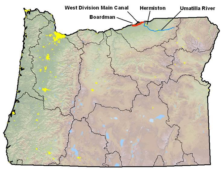
Figure 2. Aerial photograph of Three-Mile Falls Dam and West Division Main Canal point of diversion from the Umatilla River
(National Agriculture Imagery Program 2005)

(refer to Figure 3 for location reference)
Figure 3. Aerial photograph of West Division Main Canal area, canal shown in red (National Agriculture Imagery Program 2005)

Figure 4. Aerial photograph of west end of West Division Main Canal, enlargement of the western most area of Figure 3 (National Agriculture Imagery Program 2005)
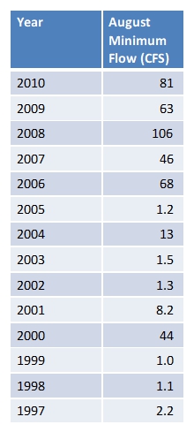
Source and timing of canal water. The West Division Main Canal draws water from both the Umatilla and Columbia Rivers. This follows from state and federal provisions for management of Umatilla River water (Oregon water rules, 1980 Northwest Power Act and 1988 Umatilla Basin Act) and decisions of natural resource managers who implement these provisions. The current fish-flow goal for the lower Umatilla River, established in 2006, is to maintain at least 250 cubic feet per second instream most of the year, and at least 75 CFS instream during July 1- Aug. 15, if climatically available and not otherwise appropriated – typically available in-river flow does drop below 75 CFS in August. Umatilla River target flows are measured at the river mile 2.1 US Geological Survey gage below Three-Mile Falls Dam. In order to maximize instream flow towards meeting these targets, the Umatilla River diversion into the West Division Main Canal is replaced by Columbia River water when the Umatilla River falls below target flows. The USBR provides 'exchange' flow (Umatilla Basin Project) to the canal from the Columbia River rather than from the Umatilla River during this time. The exchange has been operational since the 1980s. Beginning in 2006, Basin aquatic resource managers substantially increased their emphasis on not de-watering the Umatilla River in July-August below Three-Mile Falls Dam, as indicated in Table 1.
Table 1. Time-series minimum August flows in Umatilla River below Three-Mile Falls Dam
(gage data from Oregon Water Resources Department –US Geological Survey gage at river mile 2.1)
The Columbia River exchange input to West Division Main Canal (Figure 5) is located approximately two miles down-canal from the Umatilla River point of diversion. In addition, the district may pump supplemental water from the Columbia River pool via a pumping station at the Umatilla River's mouth. The location of supplemental input to the canal is also shown in Figure 5. The designated irrigation season is March 1 through Oct. 31, but the canal usually runs March 15 through Oct. 31. Based on these factors, the West Division Main Canal typically derives water from the Three-Mile Falls Dam pool on the Umatilla River from mid-March through mid-June or July and then from the Columbia River at or near the city of Umatilla from then until Oct. 31. Normally, no water is routed to the canal between Nov. 1 and Feb. 28.
Figure 5. Location of inputs to the canal, from Columbia River
(National Agriculture Imagery Program 2005 and Oregon Water
Resources Department on-line photos)

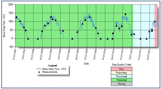
Volume of canal input water. Canal input flow typically ranges from 30 to 175 CFS (Figure 6) during the growing season, as measured in the canal below the Columbia River inputs (gage #14032650, Figure 5). This lower gage assesses the entire flow entering the canal, as it is located below all three river source inputs, and diversion is minimal above this gage. Lower flows occur near the beginning and end of the irrigation season.
After the Umatilla River diversion is closed, sluggish standing water remains in the uppermost canal section due to seepage through the headgate below the Three-Mile Falls Dam fish bypass facility. This slack water extends down-canal roughly one mile to a ramp-flume. This flume backs up Umatilla River water and then drops to where the Columbia River water circulates up-canal from its point of introduction, during the remainder of the irrigation season.
Much of the canal-proper is dry in the off-season. The district typically conducts essential annual maintenance on the West Division Main Canal during this dry period. During the off-season, water may pond temporarily behind the check dams and in certain areas groundwater enters the canal. Groundwater input occurs primarily in areas 15 miles from the Umatilla River head gate and near Boardman.
Volume of overflow. The overflow exiting the end of the constructed channel ranges from zero to 30 CFS during the irrigation season. Some of this is consumed through ten water rights downstream from the end of the constructed channel. These water rights rely on diversion directly from the overflow channels.
Year round, the West Division Main Canal's return flow entering the Columbia River is typically 0.5 to 6 CFS, with the district targeting 3 to 6 CFS during the irrigation season. The overflow channel system, developed in 1916, appears to follow a natural topographic low, and thus, may have historically served as a drainage-way for the region’s infrequent runoff. During the non-irrigation season, this portion of the canal has some sections that contain small amounts of water, which is from ground water inflow of seasonally applied irrigation water and thus is not a natural condition. This water continues to seep into the overflow channel during the non-irrigation season due to a lag-effect caused by the slow rate of groundwater transport.
Figure 6. Recent years discharge for West Division Main Canal just downstream from the points of Columbia River input (data from Oregon Water Resources Department website, gage #14032650)
Canal structure. The canal's point of diversion, Three-Mile Falls Dam on the Umatilla River, is two miles south of Umatilla, Oregon, and has a structural height of 24 feet, a hydraulic height of 23 feet, and a crest length of 915 feet. The canal is a trapezoidal channel that is approximately 28 feet wide and 7 feet deep. It has a diversion capacity of 375 CFS (USBR website), though as mentioned earlier, the flows in the canal are typically 150 CFS or less. There are check dams in various places in the canal to prevent flows from traveling upstream. There are gates or valves on each delivery from the canal. The original concrete structure is a single un-branching artery. All diversions are located below the Columbia River water input except one, which is between the Umatilla and Columbia inputs (Figure 5), just above the upper Columbia River input. The city of Hermiston is collaborating with the district to re-locate this diversion to a point below the Columbia River water introduction.
The constructed channel is continuously lined with concrete for 27 miles, from the Umatilla River head gate to an overflow structure southwest of Boardman, located at the terminus of the original concrete structure (Figure 3 and Figure 9). At the head of the canal where it diverts from the Umatilla River, there is a modern rotating drum fish screen and bypass facility built in 1988 (Figure 7).
Figure 7. Fish screen at Three-Mile Falls Dam (Oregon Water Resources Department website)

Prior to the current fish screen at the canal's head, a louver screen was in place dating back to the 1960s (USBR 1985):
"The louver screen is mounted at the intake of the (West Extension Irrigation District canal) at the left abutment of the dam. It was constructed by the Bureau of Commercial Fisheries in 1961 under contract with the Bureau of Reclamation and the (West Extension Irrigation District). It is approximately 30 feet long and consists of a series of fixed metal slats spaced about 1 to 2 inches apart. It prevents most steelhead smolts from entering the canal and directs them to the entrance of the bypass pipe."
At the lower end of the constructed channel, canal water flows through two overflow channels, and then these flows reconnect. These overflow channels consist of roadside, field and golf course ditches and drains. The resulting single channel then flows past the Boardman I-84 Rest Area, and under a railroad track to the Columbia River.
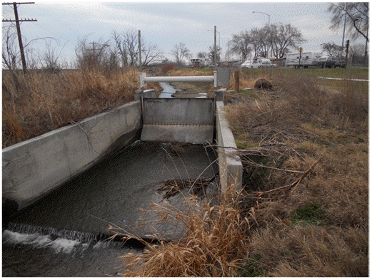
Personal communication with the district and Oregon Department of Fish and Wildlife staff indicate that in 2002, a fish barrier (Figure 8) was installed near the end of the final overflow channel (Figure 4), 0.1 mile from its entrance to the Columbia River. Prior to this, fish were prevented from entering the drainage system by a large concrete irrigation box that blocked passage down-canal from the existing barrier. This irrigation box was part of the original irrigation system built in 1916. However, with the inundation of land via the John Day Dam (completed in 1971), irrigation ceased on these lower grounds. By the late 1990s, the box had degraded and the canal over-flow had eroded a channel around it. A few stray fish were noted above the Interstate-84 rest area (below the golf course shown in Figure 4). District staff believe that fish did not move upstream above this point, based on the presence of additional barriers and lack of reported observations above those barriers. The 2002 fish barrier was installed as a measure to prevent fish from entering the canal system. This existing structure is described by the district manager: "This is 1.5 miles downstream of our main canal. We had the Oregon Department of Fish and Wildlife design the structure. The area is limited by the two culverts - one under I-5 and one under the railroad tracks. There is a 4-foot elevation difference between the two culverts. So, our gate is set at a minimum three-foot height. The ramp (on the downstream side of the gate) falls an additional foot. Water sheets over the ramp typically, so fish are not able to swim upstream. We have never noticed fish coming up since we put this in. Landowners upstream from this area confirm."
Figure 8. Fish Barrier near end of canal overflow channel (2011 photo, DEQ)
(Boardman Interstate-84 Rest Area is visible in background)
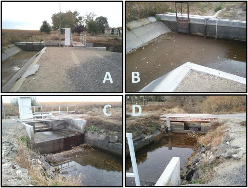
Properties and history of overflow channels. The overflows are earthen channels, except where irrigators added concrete-lining along the east-west segment exiting the constructed channel after the 1916 USBR canal construction. The channels were constructed/developed by the USBR to release overflow. According to the district, this added concrete lining occurs along the east-west part of the uppermost east-west overflow branch. The length of the overflow channel system, from the constructed channel to the Columbia River, is approximately two miles (1.5-mile direct line to Columbia River). Figure 9 illustrates the overflow structure at the downstream end of the constructed canal (original concrete structure).
Figure 9. 2011 photos (DEQ) of the downstream end of original concrete canal structure.
(A) View toward west, (B) close-up of west-exit gate in 'A', (C) view toward southwest of north-flowing outlet, (D) view toward north, of lower part of the northern outlet.
The overflow channels descending from the constructed channel were developed to generally follow the natural topography. DEQ believes that the natural topographic low sections may have drained infrequent runoff, but were typically dry. This conclusion is based on conversations with the district concerning canal history, and on the area geomorphology and hydrology. The oral history, though minimal with regard to hydrology, suggests that these were dry drainages most of the time. The valley form can be approximately assessed through digital elevation (US Geological Survey digital elevation model) based on USGS 7.5 minute quadrangle topographic maps (Figure 10). Figure 10 depicts an apparently natural y-shaped drainage extending northward from the west-trending canal, containing the modern overflow.
Figure 10. Topographic illustration of West Division Main Canal (US Geological Survey Digital Elevation Model, a digitized 7.5-minute topographic map portrayed with inclined illumination to highlight topography).

The lack of channel definition near the modern Columbia pool shoreline is not consistent with an active channel. In addition, the drainage area is much smaller than neighboring drainages that generally exhibit no flow, except during storms or where agricultural drains enter. Nor were these likely flowing more frequently in historic times. The water table now, due to irrigation, is almost certainly higher than pre-irrigation times. This is because the rainfall in the area is slight in the area and mountain recharge areas are distant. From 1971-1975, the annual average precipitation was 8.6 and 10.4 inches at Boardman and Hermiston (National Oceanic and Atmospheric Administration). Due to the aridity, low topographic relief and young geology, the area has not undergone stream network development. This is strikingly apparent in a view of the area hydrography (Figure 11), in which the West Division Main Canal area is relatively void of streams. In summary, the overflow channels have been agricultural drains for nearly 100 years and otherwise would have no water except infrequently due to storms or snowmelt.
Figure 11. Map of area stream network, 1:100,000 National Hydrography Dataset

3.2 Canal History
The Umatilla Basin Project. The West Division Main Canal was authorized by the Secretary of the Interior on Dec. 4, 1905, under provisions of the original Reclamation Act, section 4, (32 Stat. 388). The authorized project purpose was irrigation.
The USBR built the Three-Mile Falls Diversion Dam in 1914. The West Division Main Canal was excavated, lined and completed in 1915-1916, via congressional authorization to the USBR. The canal has been operated by the district since April 27, 1926. The constructed channel is entirely human-made – it was not a natural waterbody and did not follow the course of a natural waterbody.
Congress, by the Act of Sept. 6, 1966 (80 Stat. 707, Public Law 89-561) authorized the Secretary of the Interior to conduct a feasibility investigation to expand the area irrigation base and to address anadromous fishery needs. A proposed plan that included additional storage facilities was developed, however it was not authorized. Subsequently, through a cooperative local, state, tribal (Confederated Tribes of the Umatilla Indian Reservation), and federal effort the Columbia River water exchange plan was developed to help resolve fishery and irrigation water needs in the Umatilla River basin. The Umatilla Basin Project (Umatilla Basin Act of 1988) provides for an exchange of water for area irrigation from the Columbia River instead of the Umatilla River. The Umatilla Basin Project has been heralded as the most successful stream flow restoration, salmon recovery and irrigation project in the Columbia River basin.
Authorized by Congress under the 1988 Umatilla Basin Act, the project re-engineered the water supplies for three of the four lower Umatilla Basin Irrigation Districts—Stanfield, Hermiston and West Extension Irrigation Districts. When the project was completed in the mid-1990s, those three districts began taking their water from the Columbia River, rather than the Umatilla River, at ecologically-strategic times of year. Special regulations under Oregon’s water laws enabled an “exchange” of water supplies. This exchange is the basis for the alternating river sources for West Division Main Canal water.
The information source for this section and further documentation can be found at http://www.usbr.gov/projects//ImageServer?imgName=Doc_1305644113536.pdf,
http://www.usbr.gov/projects/Project.jsp?proj_Name=Umatilla+Basin+Project, http://oregonwatercoalition.org/blog/?p=86.
Additional history is provided in Section 2.1, regarding fish barriers and flow management.
3.3 Canal Uses and Management
The canal is used to transport water from the Umatilla and Columbia Rivers to area farms for crop irrigation, including commercial food crops for human consumption and animal-feed, and also provides for some livestock watering. Edible crops grown with the irrigation water include grain, fruit, and vegetables. Irrigated animal-feed plants include hay-pasture-alfalfa. The irrigation district manager describes the canal use as, "There is no hunting or boating. Farmers have livestock watering rights from the canal. Swimming or other human use of the canal is prohibited and is very hazardous. Gates are at most public access points of the canal to prevent unwanted vehicle access. Walking and horseback riding are allowed along the canal road. Industrial water supply does not occur. The water is used solely for irrigation and stock watering." Much of the irrigation occurs via center-pivot crop circles.
Management to exclude aquatic life. The West Division Main Canal is managed to exclude aquatic life in order to protect fish, which would likely not survive if they entered the canal, due to the absence of habitat, adequate flow and appropriate water quality conditions. As described earlier, fish barriers have been in place at the Umatilla River point of diversion and at the downstream end of the canal since the 1960s and earlier. Water from the Columbia River is pumped uphill to the canal and enters the canal at two points. The pumps and their screens preclude fish passage. In addition, the canal is maintained by routine application of aquatic pesticides, consistent with the district’s individual NPDES permit for pesticide application. Both acrolein and copper sulfate are used in the West Division Main Canal to minimize nuisance aquatic weeds. These pesticides lead to toxic conditions for fish, one important reason that the district actively manages the canal to exclude fish from the system. The district has used acrolein and copper sulfate in the canal since 1958. DEQ notes that the district's NPDES permit requires that pesticide applications occur consistent with the label instructions and includes controls and monitoring to ensure that pesticide residuals do not reach the Columbia River. Finally, there are extended periods each year when large portions of the canal contain no flowing water.
Proximity to human population. As can be seen in Figure 3 the canal passes through a rural agricultural landscape with some farmsteads and other rural residences. At only one point does the canal flow through a residential area – along the southwestern border of city of Umatilla (Figure 12). Here, vehicular access is controlled and warning signs are present, though physical restrictions do not entirely prevent entry (Figure 13). The lower overflow channel flows through the Boardman golf course. Beyond this, the canal landscape is entirely rural.
The canal is owned by the Bureau of Reclamation and managed by the West Extension Irrigation District. Swimming and boating are prohibited. No drinking water rights exist for the canal. Access to the canal is restricted at strategic locations via locked gates. There is limited access for walking and horseback riding.
Canal maintenance. Workers periodically enter the canal for repairs and cleaning. This generally takes place in the off-season, but may occur to a limited extent during irrigation. Aquatic weeds are managed via herbicide application as mentioned previously. In addition, at the end of the season headwater sedimentation is removed from the upper part of the canal at and below the Umatilla diversion headgate. This occurs partly via a flushing with Umatilla River water. The Umatilla headgate is opened and water is flushed from there to a concrete "cleanout" outlet at the city of Umatilla, where the flushed water enters the Columbia pool backwater in the Umatilla River channel near its mouth.
Figure 12. West Division Main Canal adjacent to the city of Umatilla (National Agriculture Imagery Program 2005)
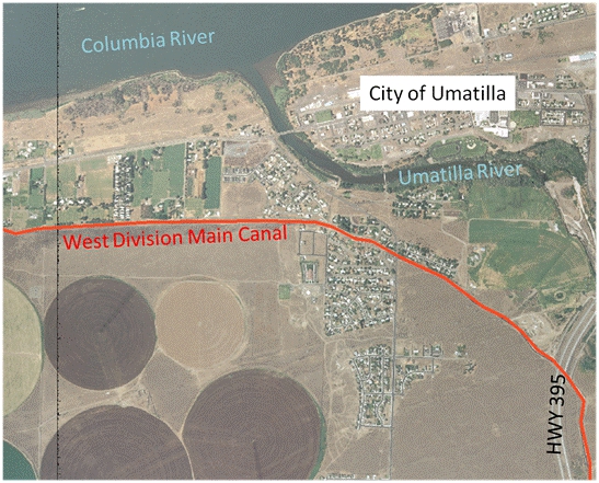
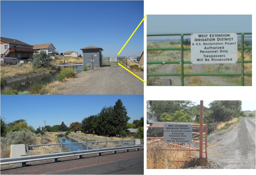
Figure 13. Canal signage and access controls, canal bridge crossing at Umatilla, Oregon (DEQ 2011)
Constructed channel and overflow channels. The main channel of the canal has different properties than the overflow channels, as mentioned previously. The overflow channels are generally not lined with concrete, except for parts of the west-trending section just downstream of the main constructed channel. Unlike the lined parts of the canal, the un-lined parts have earthen substrate and banks and are bounded by soil and vegetation – farm fields, farmhouse yards, golf course lawn and some trees - willow, locust, russian olive, alder and cottonwood. At a lower elevation and with more permeable channel material compared to the constructed channel, the overflow reaches interact more with groundwater, i.e., ground water flows into the overflow channel. The overflow channels are not as removed from the surroundings in the way that the constructed channel is with its concrete, berms and roadway. Accordingly, the overflow channels are somewhat more likely to be used by people, birds and other wildlife. This is part of the reason that DEQ is proposing to retain the designated beneficial uses of water contact recreation and wildlife and hunting. In addition, as stated in Chapter 3, a modified form of aquatic life use is proposed for the overflow channels.
Although the overflow channels have less hard structure than the constructed channel, suitable conditions for aquatic life and other non-agricultural uses are limited in both, and entirely absent in the constructed channel. The purpose of the overflow channels, and the only reason for the presence of water in them, is to function as an agricultural drain. The overflow channels do not have the natural channel form that results from the cyclicity of winter-spring floods and summer-fall declines in flow. They are predominately field and road ditches and are maintained as such – straightened, cleaned and graded, with little pool form, sinuosity or channel complexity. As with the constructed channel, water is withdrawn from these ditches to serve water rights. Fish are prevented from accessing the overflow channels by the downstream fish barrier between the interstate and the railroad that borders the Columbia pool. Further, domestic water rights are not available for any part of the canal, nor is it feasible that they would be in the future. There is generally insufficient water for boating and it is prohibited.
3.4 Policy Background
Section 2.4.1 identifies policies and rules that are directly related to the proposed standards revision. Section 2.4.2 provides background related to canal maintenance and permitting and the city’s proposed discharge to the canal, which is separate from DEQ’s proposed water quality standard revisions. The Section 2.4.2 background regarding the canal's NDPES permit and city's planned effluent treatment is included here as supplemental information.
3.4.1 Standards Revision
3.4.1.1 Use Change Guidance
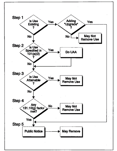
State and federal rules and guidelines identify considerations and requirements for changing designated beneficial uses in state water quality standards. These include Title 40 Code of Federal Regulations 131.3 and 131.10 (the latter is included as Appendix 8.2), the Federal Register for EPA’s water quality standards regulation (November 8, 1983; Vol. 48, No. 217, p051400-51413), the 2007 DEQ Use Attainability Analysis and Site-Specific Criteria Internal Management Directive, and the EPA 1994 (with some 2007 updates) Water Quality Standards Handbook (second edition). The 1994 EPA handbook contains the following flow chart for changing designated uses (Figure 14) outlining the process DEQ is using in the proposed canal use revision.
Figure 14. Flow of logic in use change process (EPA 1994)
3.4.1.2 Changing Designated Uses – Requirements and Approach
States may remove designated beneficial uses that are not existing uses. States may not remove existing uses, as defined in 40 CFR 131.3, unless a use requiring more stringent criteria is added [40 CFR 131.10(h)(1)]. Existing uses are defined as "... those uses actually attained in the waterbody on or after Nov. 28, 1975, whether or not they are included in the water quality standards." [40 CFR 131.3(e)]
EPA has further stated that the definition of "existing use" can consider the available data and information on both the actual use and water quality. With regard to the canal, the relevant historic water quality data (1970s) is not available. EPA has indicated (EPA 2008) that in such circumstances, a state may choose "to determine an existing use based on the strength of evidence that a use has actually been achieved or the strength of evidence that water quality supporting a use has been achieved." DEQ’s analysis focuses on whether the use has actually occurred or may occur in the future in the absence of historic water quality data (during and after 1975). Beneficial uses focused on the protection of fish are an example. As described in Section 3, the canal screens are designed to protect fish by excluding them from the biologically harsh conditions of the canal (water withdrawal, stranding, lack of habitat, etc.) – to protect endangered fish populations.
In addition, EPA (2008) states "Where the water quality achieved was sufficient to support a use on or after Nov. 28, 1975, but the use (i.e., some degree of use related to aquatic life, wildlife, and human activity) has not occurred, the federal regulations provide states and tribes the discretion to determine whether or not this is an existing use. In this case, however, it would be reasonable to presume the use is attainable and that a state or tribe would need to explain the factors unrelated to water quality (e.g., human caused conditions that cannot be remedied, hydrologic modifications) that are limiting the attainment of the use before it can be removed..." This explanation is provided in Section 3.
Federal regulations (40 CFR 131.3(g)) state that a "Use attainability analysis is a structured scientific assessment of the factors affecting the attainment of the use which may include physical, chemical, biological, and economic factors as described in 40 CFR 131.10(g)." 40 CFR 131.10(j) specifies that a state must conduct a use attainability analysis as described in 40 CFR 131.3(g) whenever:
• The state designates or has designated uses that do not include the uses specified in section 101(a)(2) of the Clean Water Act, or
• The state wishes to remove a designated use that is specified in section 101(a)(2) of the Act or to adopt subcategories of uses specified in section 101(a)(2) of the Act which require less stringent criteria. The uses in 101(a)(2) of the Act are "protection and propagation of fish, shellfish, and wildlife and provides for recreation in and on the water."
EPA regulations state that at a minimum, uses are deemed attainable if they can be achieved by the imposition of effluent limits required under sections 301(b) and 306 of the Act (point source controls) and cost-effective and reasonable best management practices for nonpoint source control (40 CFR 131.10(d)). At this point in time, there are no point source discharges to the canal other than the herbicide application to the canal, for which the irrigation district holds an NPDES permit. The imposition of effluent limits required under section 301(b) and 306 of the Act and cost-effective and reasonable best management practices for nonpoint source control would not support fish and aquatic life use in the canal, where the physical configuration and canal operations are the limiting factors. This is true of boating and domestic water supply as well. Should the city of Hermiston relocate its treatment plant discharge to the canal, DEQ will include the applicable requirements in the NPDES permit.
In brief, existing uses are prohibited from being removed, and removal of the statutorily (CWA 101(a)(2)) identified uses requires a structured scientific analysis referred to as a use attainability analysis. These requirements relate to the West Division Main Canal standards revision as follows:
1. DEQ is not removing existing uses from the use designation.
2. DEQ is not removing attainable uses from the use designation. DEQ’s conclusions in this regard are based on the artificial physical nature of the waterbody, which is constructed and modified, its known use and the purpose for its construction and operation.
3. DEQ is correcting a past, unintentional over-designation of uses for the canal.
4. DEQ proposes to remove the currently designated uses related to aquatic life, which are identified in section 101(a)(2) of the Act, as these uses are inconsistent with the intended use, purpose and management of the canal, and are not existing or feasibly attainable uses. DEQ proposes to replace these uses with a modified aquatic habitat use for the overflow channels segment. Other uses will be removed as well, as discussed in Section 3.
5. DEQ is proposing revised uses for the canal that will require less stringent criteria.
This report constitutes a use attainability analysis. It includes sufficient information as to whether uses are existing or attainable, given that the canal's operations, controls, purpose and artificial nature are straightforward and dictate the type of uses that are existing and attainable. DEQ's use attainability analysis internal management directive (DEQ 2007) states "DEQ anticipates that there will be situations in which the use attainability analysis will not require all of the technical information described in this chapter [for a more exhaustive use attainability analysis]. This may be the case if: the designated use is not an existing use, the designated use is not necessary as a goal for the waterbody, the proposed changes to a designated use are corrections to the water quality standards..." All of these conditions are true for the West Division Main Canal. This use attainability analysis, as stated in item 2 above, is focused on the artificial nature of the canal and its known and intended use and operations. Discussions with EPA further indicate that the needed level and type of information for a use change should be commensurate with the type and degree of use change. For example, a use designation correction, as is being applied to the canal, is a different context from non-attainment based on unachievable water quality. As another example, more information should be required where there is potential for highly sensitive uses, such as where waterbodies are natural, perennial and contain species (or designated critical habitat for species) listed under the Endangered Species Act – none of which are true for the West Division Main Canal.
3.4.2 Related Policy
3.4.2.1 Canal Return Flow NPDES Exemption
In Oregon, the NPDES program administered by DEQ covers discharges to surface waters of the state, which includes irrigation canals. Discharges consisting of irrigation return flow and agricultural stormwater are exempt from NPDES permitting requirements [Clean Water Act Section 402(1), 502(14)]. As such, irrigation return flow and agricultural stormwater flows into the West Division Main Canal and return flows from the canal to the Columbia River are exempt from NPDES permitting requirements. In addition, according to the Oregon Attorney General's Office, the NPDES-permitted discharge of treatment plant effluent by the city of Hermiston does not remove this exemption. "Simply put, the existence of permitted discharges to receiving water does not change the nature of the exempt discharges or the nature of the receiving water itself" (Oregon Department of Justice 2010).
3.4.2.2 Class A Recycled Waters
In Oregon, land application of recycled water, i.e., wastewater re-used for crops, may be applied to human-food crops that are eaten uncooked if it is first treated to "Class A" levels. Oregon Administrative rules (OAR 340-055-0012) define various classes of recycled water in terms of treatment levels and allowable uses. Class A waters may be used for irrigation for any agricultural or horticultural use. There are examples of Class A (or an equivalent treatment level) recycled water irrigation for food crops elsewhere in the US. Class A waters must be oxidized, filtered, disinfected, and must meet specified stringent numeric limits for total coliform bacteria and turbidity. Given the similarity between direct land application for growing crops and discharge to an irrigation system, the city of Hermiston is planning to treat their municipal wastewater to Class A standards. This exceeds the level of treatment generally needed to meet water quality standards for bacteria.
3.5 Authorities
The following entities have authority over various aspects of the canal, water quality standards and the Hermiston wastewater treatment plant.
• West Extension Irrigation District: manages canal under a contract with the USBR
• City of Hermiston: the city is responsible for the wastewater treatment plant and its discharge, and NPDES permit compliance
• USBR: the canal has a federal easement pursuant to the 1890 Reclamation Act. In addition, the irrigation project is owned by the USBR. Wastewater discharge to the canal requires a permit through the USBR in addition to the NPDES permit that DEQ administers for wastewater discharges to “waters of the state.” Preparation of the USBR permit is underway, and a draft National Environmental Policy Act environmental assessment has been completed.
• DEQ: adopts and implements Oregon water quality standards; issues and enforces NPDES permits
• EPA: approves water quality standards and oversees DEQ’s NPDES permits
4 Revision of Designated Uses for Canal
This section identifies the proposed changes to the West Division Main Canal designated beneficial uses and the rationale associated with the changes.
4.1 Geographic Scope of Standards Revision
DEQ proposes to revise the water quality standards that apply to the West Division Main Canal. The canal consists of two segments. The majority of the canal (27 miles) is the original constructed concrete structure (constructed channel). The second segment consists of overflow channels that extend from the downstream terminus of the constructed channel to its outflow into the Columbia River. Most of the proposed revised uses and the proposed criteria for irrigation and livestock watering uses will apply to both segments of the canal. However, for the overflow channels segment, DEQ also proposes a modified aquatic habitat use (defined in Chapter 5) and associated criteria. Figure 3 illustrates the full waterbody.
4.2 Historically Designated Beneficial Uses
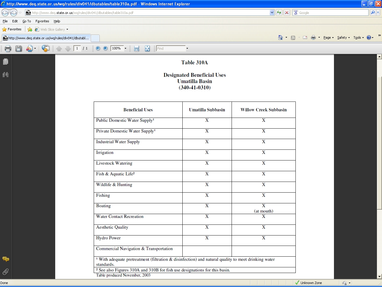
Historically, DEQ designated uses by basin or subbasin. DEQ designated all, or nearly all, uses for every basin with only a few exceptions, such as commercial navigation and transportation where it was clearly not suitable. These designations did not represent DEQ's or the commission's conclusion that every reach of every waterbody within each basin was suitable and should be protected for every use, including constructed canals. DEQ expects that the intent at that time was to assign uses broadly since the uses either existed or warranted protection in at least some if not most of the waters within the basin. The current designated uses for the Umatilla and Willow Creek Subbasins are listed in Table 310A (below) and adopted by reference in OAR 340-041-0310. While much of the canal lies between the Umatilla and Willow Subbasins (in the Mid Columbia - Lake Wallula drainage), DEQ interprets the Umatilla Subbasin column of Table 310A to include the canal as well.
4.3 Existing Uses
DEQ evaluated the existing uses of the West Division Main Canal and concludes that the existing uses for the constructed channel are limited to:
• Irrigation
• Livestock watering
• Wildlife and hunting (as an aggregate category for limited waterfowl use, but hunting does not occur)
• Infrequent water contact
• Aesthetic quality
Each of these existing uses has been previously designated as a beneficial use of the canal for water quality standards and is being retained with this action. Irrigation, livestock watering and infrequent water contact have occurred in the canal on and after Nov. 28, 1975. Aesthetic qualities are present as well. The primary intended use and purpose of the canal is for irrigation. Canal water is also used for livestock watering. DEQ identified these existing uses based on the knowledge and professional judgment of the district, USBR, Oregon Department of Fish and Wildlife and DEQ staff with input from the public. The existing uses are consistent with the features and operations of the canal, the fact that it is a constructed canal (and was never a natural stream or waterbody), and the intent and purpose for its construction and operation.
The existing uses of the overflow channels are the same as those listed above for the constructed channel except that it is reasonable to conclude that limited aquatic life may be present at times in the overflow channels. This is discussed further below. Water contact (human) occurs infrequently, primarily for the purpose of canal maintenance activities. Swimming is prohibited and public access to the canal is limited, as described in Section 2.3. It is possible that some incidental water contact by children or other people could occur, particularly where the canal passes through a city of Umatilla residential area (Section 2.3), where canal water is applied for lawn watering (cities of Umatilla, Irrigon and Boardman) or in the overflow reaches. Water contact recreation will continue to be designated as a use.
Wildlife is considered an existing use primarily due to temporary presence of waterfowl. Hunting does not occur along the canal. However, for the sake of simplicity and potential future use, wildlife and hunting will continue to be designated as a use.
In the context of designating beneficial uses, states must determine what level and quality of aquatic life comprises the 'existing' use. With regard to the constructed channel, DEQ acknowledges that there are likely transient or temporary, tolerant organisms that use the water. However, this incidental, marginal aquatic life does not equate to the aquatic life use stated in section 101(a) of the CWA: the “protection and propagation of fish, shellfish and wildlife.” Any aquatic organisms found within the constructed channel would be considered part of a marginal population, at best, and would not be capable of sustaining a stable population due to the hazards and habitat deficiencies of the canal. The objective of the Clean Water Act, stated in Section 101(a), is “to restore and maintain the chemical, physical and biological integrity of the Nation’s waters.” The chemical, physical and biological integrity of the canal does not constitute habitat for a stable, balanced or indigenous biological community. DEQ’s perspective with regard to the WEID canal does not necessarily translate to similar future actions to remove aquatic life designations from all concrete channels or highly modified systems. For instance, urban streams that have been channelized may be restorable, or may be conduits to areas of better habitat – this is not true of the canal, due to its barriers and design function of transferring water to fields, a purpose that is inherently hazardous to fish.
The overflow channels are also operated as part of the irrigation system (withdrawals, cleaning, ditching, fish barriers) and have the same existing and attainable uses as the constructed channel (refer to Section 3.4), except that DEQ proposes to adopt a modified aquatic habitat designation for the overflow channels. While the overflow channels do not support cold-water aquatic life, there may be potential for limited aquatic life use, given that much of this segment is earthen rather than concrete-lined and that some habitat features, such as vegetated banks, are present. DEQ does not have biological data for the canal. The existing aquatic life in the overflow channels is expected to be very limited and characteristic of a modified, warm water body that flows seasonally in response to irrigation upstream, contains primarily tolerant species that do not resemble the natural aquatic community of a reference stream, and contains no cold water fish. Therefore, DEQ concludes that any existing aquatic life use is best characterized by a subcategory of modified aquatic habitat (defined in Chapter 5).
DEQ's interpretation of aquatic life use, for the purpose of establishing water quality standards, is a self-sustaining or reproducing (“propagating”) population(s) of aquatic organisms that represent native aquatic communities and, therefore, the biological integrity of the waterbody. This is consistent with the CWA and federal regulations and policy. In addition to the CWA citations above, the following references support this interpretation:
• EPA's 1994 Water Quality Handbook (Chapter 4), states that small marginal populations may not constitute an existing use. Chapter 4 also provides "A use attainability analysis or other scientific assessment should be used to determine whether the aquatic life population is in fact an artifact or is a stable population requiring water quality protection.
• 40 CFR 130.7(b)(2) and (c)(2) refer to CWA objectives of "water quality criteria for protection and propagation of a balanced, indigenous population of shellfish, fish and wildlife..."
This interpretation is supported in the DEQ policy and documents:
• OAR 340-041-0028 (2) Policy. It is the policy of the Commission to protect aquatic ecosystems from adverse warming and cooling cause by anthropogenic activities. The Commission intends to minimize the risk to cold-water aquatic ecosystems from anthropogenic warming, to encourage the restoration and protection of critical aquatic habitat, and to control extremes in temperature fluctuations due to anthropogenic activities.
• From OAR 340-041-0002 Definitions:
(19) “Ecological Integrity” means the summation of chemical, physical and biological integrity capable of supporting and maintaining a balanced, integrated, adaptive community of organisms having a species composition, diversity and functional organization comparable to that of the natural habitat of the region.
(50) “Resident biological community” means aquatic life expected to exist in a particular habitat when water quality standards for a specific ecoregion, basin or waterbody are met. This must be established by accepted biomonitoring techniques.
• OAR 340-041-0011 Biocriteria. Waters of the state must be of sufficient quality to support aquatic species without detrimental changes in the resident biological communities.
• OAR 340-041-0016 Dissolved Oxygen. Table 21 describes uses as biological communities, made up of multiple species, characteristic of a cold, cool or warm water environment.
• From DEQ’s temperature standard internal management directive (April 2008, p.5):
"In the case of temperature, the most sensitive beneficial use is Oregon’s native cold-water aquatic communities. Cold water fish, such as salmon and trout, indicate the presence of these communities. Several temperature criteria have been established to protect various life stages and fish species, depending on their thermal requirements.
Because temperature is variable through time and space in the natural environment, DEQ and the environmental quality commission recognize that thermal conditions may not be optimal for cold water fish at all times or in all places. The policy objective in these circumstances is to minimize risk to cold-water aquatic ecosystems from anthropogenic warming. The standard is designed to minimize alteration of the natural thermal regime due to anthropogenic activity [OAR 340-041-0028(2)]."
4.4 Historically Designated Beneficial Uses that are not Existing Uses
The constructed channel designated beneficial uses, prior to this revision, that are not existing uses are:
• Public domestic water supply
• Private domestic water supply
• Industrial water supply
• Fish and aquatic life and the sub-category Redband or Lahontan Cutthroat Trout
• Fishing
• Boating
• Hydropower
In Oregon, fish and aquatic life use refers to the native cool and cold-water organisms representative of natural habitats and that are reproducing or sustainable. This is not the existing aquatic life use in either segment of the canal. For the overflow channels, a limited or modified aquatic life use may occur, as the overflow channels are not as completely devoid of habitat as the constructed channel. Therefore, DEQ proposes to designate a modified aquatic habitat use for the overflow channels as stated in Section 3.1.
The canal has never been used for either public or private domestic water supply or industrial water supply. The basis for this statement is DEQ’s review of the water right certificates for the district, and personal communications with the irrigation district manager and the Oregon Water Resources Department area water master, confirm that domestic water supply (either public or private) is not an existing use of the canal. Water rights certificates (the legal documentation of allowable use of water appropriated from streams under Oregon water law) is not an existing use of the canal. All of the district's certificates have limited the use of the canal water since priority dates ranging from 1893-1973, and all are exclusively for irrigation and livestock use, except for one. The exception is a certificate (79932) with1893 priority date, which allowed domestic use in addition to irrigation and stock water. Certificate 79932 applies to 46.25 acres of land owned by the Army Corps of Engineers, with no water delivery infrastructure. This acreage is within the land condemned by the Army Corps of Engineers for the purpose of reservoir (John Day Dam - Lake Umatilla) development and associated management, and in fact may be inundated. Regardless, the district considers the certificate cancelled and the Oregon Water Resources Department considers it inactive. The district and the canal have never provided service via this certificate, nor does the district believe they legally or feasibly could. In summary, drinking water is not allowed, by law, and this has been the case continuously since 1973 and earlier and the canal has not been used for industrial water supply.
Future use of the canal for non-agricultural purposes is highly improbable as well (2011 personal communication with water master). Further, it is common knowledge that irrigation canals are not used for domestic water supply and would not be safe for drinking. The water rights certificates are available on-line in Oregon's Water Resources Information System (Water Resources Department). The certificates for the West Extension Irrigation District are as follows:
Certificate Number |
Use | Priority Date |
79924 | Irrigation, Livestock | 1893 |
79925 | Irrigation, Livestock | 1906 |
79926 | Irrigation | 1909 |
79927 | Irrigation | 1962 |
79928 | Irrigation | 1968 |
79929 | Supplemental Irrigation | 1968 |
79930 | Irrigation | 1969 |
79931 | Supplemental Irrigation | 1973 |
79932 | Irrigation, Domestic Use, Stock Water | 1893 |
79933 | Irrigation, Stock Water | 1906 |
79934 | Irrigation | 1909 |
Fish and aquatic life, the cool and cold water aquatic organisms native to and sustainable within Oregon waters, is not an existing use in the canal. Fish screens and management measures to exclude aquatic life have been in place since well before 1975 and will be continued, as described in Section 2.2. Appendix 8.3 is a letter from the Oregon Department of Fish and Wildlife, Umatilla district fish biologist, documenting that the canal does not have Redband or Lahontan cutthroat trout and that the trout use designation is incorrect. While the letter addresses periods of 1988-2002 and later, the irrigation district manager has stated that earlier screens and fish barriers have been in place since the 1960s and earlier. Additional information on the canal structure and management as well as the fish screens is provided in Chapter 2.
Fish screens notwithstanding, the artificial nature of the constructed channel, its purpose and the adverse habitat it would provide – preclude aquatic life as an existing use. The canal is not a suitable environment for aquatic life, and the absence of suitable habitat for fish would likely lead to mortality. Being a constructed, concrete-lined canal built for the purpose of conveying irrigation water, the canal lacks the necessary habitat elements of substrate, pools, refuge, shade, vegetation and stream flow that would be appropriate for fish and other aquatic life. These habitat elements are not an attainable condition for the constructed channel, given that it is concrete-lined.
Further, the canal contains flowing water for only portions of the year, with large portions of the canal dry or void of flowing water from November through February. The flow in the canal is present solely for irrigation purposes and is diverted from the river under irrigation water rights. During the irrigation season when the canal is flowing, large amounts of water are removed from the canal for use in center pivot sprinkler irrigation systems, presenting a severe hazard to any aquatic life in the canal. During the non-irrigation season, water is not diverted into the canal and the canal is dewatered and contains only isolated sections of standing water. Finally, pesticides have been applied to the canal on a regular basis since acrolein was first applied in1958 (four to six treatments per year) to prevent the growth of aquatic plants and algae. This activity is also harmful to aquatic organisms (Section 2.3). Consequently, the canal conditions are inhospitable and often lethal for fish and other aquatic life.
For reasons stated in the previous paragraph, and because fish access to the canal has been limited since well before 1975, fishing is not an existing use. The canal is not stocked and fishing is prohibited. In addition, public access is blocked for most of the canal's length.
Boating in the canal is prohibited and has not been allowed since the canal was constructed (personal communication with the district). Access along much of the canal is blocked, there are no boat ramps or “put-ins” and the fish barriers effectively prevent accidental entry (Section 2.3). Hydraulic fluctuations, hazards and check dams combine to make boating inappropriate and unsafe. Much of the canal is too small for boating or has too little or no flow for large portions of each year. The canal passes underground beneath Interstate I-84 via a siphon. The canal was not designed or intended to be used for boating. Boating is not an existing use.
Overflow channels. As described in Section 2.3, the overflow channels have some different properties than the constructed channel, and access is less restricted. However, even the earthen overflow channels lack the substrate, channel form and vegetative attributes of a natural stream, given that the system consists largely of field and road ditches that are maintained as such. These channels are managed to exclude fish (recall that the fish barrier is close to the mouth of the final overflow channel) and natural channel features such as pools, sinuosity are generally lacking and ditch maintenance practices would be damaging to any invertebrate population. While the definition of 'existing use' is based on usage during and after 1975, DEQ believes that the historic nature of the system adds context to the determination of uses. Water is present in these channels almost entirely because irrigation water is diverted into the constructed channel from the Umatilla and Columbia Rivers. It is unlikely that the overflow channels historically flowed except as rare storm run-off (Section 2.1 – Properties and History of Overflow Channels). With regard to fish, the overflow channels have been separated from the Columbia and Umatilla Rivers by fish barriers at the upper and lower ends of the canal since well before 1975. Also, though not to the same degree as the constructed channel, the overflow channels, which are highly modified, as described above, lack suitable aquatic habitat. And finally, as with the constructed channel, the water transfer to fields would present hazards to fish if they were present. Fish are not stocked in any part of the canal.
In addition, the other uses proposed for removal are also not existing uses of the overflow system. The foregoing discussion of water certificates and standards of usage for domestic water supply, apply to the overflow as well. Boating is not known to occur, and low water levels, road/culverts and fences render the channels unsuitable for boating. The overflow is not physically accessible by boat from the Columbia River, short of portaging over an elevated railway, the fish barrier and the interstate freeway.
DEQ has determined, for the overflow channels, that fishing (and fish presence), private domestic water supply, public domestic water supply, and boating; are not existing uses. Because the overflow channels may have limited habitat value, DEQ will adopt a modified aquatic habitat use designation for the overflow channels as stated in Section 3.1.
4.5 Attainable Uses
The canal's attainable uses are the existing uses (Section 3.3) and those that have potential to exist and be supported by the purpose, structure and management of the canal and feasibly attainable water quality. DEQ has determined that the attainable uses of the canal include:
• Irrigation (existing use)
• Livestock watering (existing use)
• Wildlife and hunting (existing use)
• Water contact recreation (limited existing use, infrequent and discouraged for safety purposes)
• Aesthetic quality (existing use)
• Industrial water supply
• Hydropower
In addition, DEQ concludes that a modified aquatic habitat use may be attainable in the overflow channels. This aquatic life subcategory is newly defined in Oregon’s water quality standards with this rulemaking. It is intended to represent the limited aquatic life use supported by the existing conditions in the overflow channels, which were highly modified from their natural condition before 1975, and therefore constitutes the existing use. DEQ may apply this use subcategory to other waters of the state in future rulemakings. DEQ reviewed similar use categories used by other states to develop the following definition tailored for Oregon:
“Modified aquatic habitat” means waters in which cool or cold-water aquatic communities are absent, limited or substantially degraded due to modifications of the physical habitat, hydrology or water quality. The physical, hydrologic or chemical modifications preclude or limit the attainment of cool or cold water habitat or the species composition that would be expected based on a natural reference stream, and cannot feasibly or reasonably be reversed or abated.
The existing uses are by definition attainable at the level at which they currently exist or have existed since November 1975, according to the available information. Industrial water supply and hydropower uses do not require high water quality in comparison to the existing uses or the natural streams, such as the Umatilla and Columbia Rivers, from which the canal derives its water. DEQ believes that industrial supply and hydropower may be attainable from a water quality perspective, though it recognizes that there may be other physical and legal constraints. DEQ is not proposing any revisions to these two uses.
Of the current designated beneficial uses, some are neither existing nor attainable. These are the following:
• Public domestic water supply
• Private domestic water supply
• Fish and aquatic life/ Redband trout
• Fishing
• Boating
As discussed in Section 2.4.1.1, at a minimum, uses are deemed attainable if they can be achieved by the imposition of effluent limits required under sections 301(b) and 306 of the Act (point source controls) and cost-effective and reasonable best management practices for nonpoint source control (40 CFR 131.10(d)). These uses are not attainable in the canal due to the physical configuration (hazards and lack of habitat), purpose (the canal's serving the needs of agriculture is at odds with other uses), operations (aquatic life is excluded for its own safety) and lack of water rights for water supply currently and in the foreseeable future. The basis for this 'non-attainability' determination is the same as the basis for the 'non-existing' determination described in Section 3.4. For each of these five currently designated uses that are not attainable, the limiting factors precluding their status as existing uses will continue to be manifest into the future; as long as the canal continues to function as an agricultural canal, its sole and legally obligated purpose.
Point source controls would not support attainability, since water quality is not a limiting factor. There are no reasonable best management practices that would overcome the canal's limiting factors for these uses. DEQ notes that, in the extremely unlikely event that the canal were no longer used for applying water to the land, it would presumably have no water in it – because of the lack of water rights to do otherwise and the area demand for water. The drinking water rights limitations and boating physical limitations have no potential to change in either part of the canal. As long as the canal remains an irrigation canal, these channels are of necessity for irrigation supply and drainage. It seems very unlikely that the district would move the fish barrier further up-canal, as this would lead to fish stranding and pump and withdrawal hazards, including risks to threatened steelhead and other fish. As described in more detail in this section, these five uses are not attainable for this constructed waterbody, with the exception that modified aquatic habitat is determined to be an attainable use in the overflow channels segment of the canal.
When designated uses are removed, and particularly when the use removal leads to a change in the applicable water quality criteria, the highest attainable uses must be identified. This may be specific to a particular pollutant or water quality indicator. The highest attainable uses for the constructed channel are irrigation, livestock watering and water contact recreation (however infrequent and unlikely). The highest attainable uses for the overflow channels are the same, with the addition of the modified aquatic habitat use. To the extent that there may be wildlife use of the canal, DEQ expects that it is very limited due to the lack of natural habitat near the canal and the lack of fish or forage vegetation in the canal. Some pollutants will require more stringent criteria for one use, some for another. Section 4 provides further discussion of the proposed water quality criteria for these uses.
4.6 Proposed Revision of Beneficial Uses
This section describes the designated uses to be removed and one new use subcategory. DEQ will retain all designated uses that the agency concludes are existing or attainable as described previously. The uses DEQ proposes to remove are not existing uses and are not feasibly attainable. Within the context of a use attainability analysis, Federal regulations (40 CFR 131.10(g)) require that one of six feasibility conditions be met in order to remove a non-existing designated use. These are referred to here as 131.10(g) factors, or simply factors. DEQ relied on the following 131.10(g) factors for this use revision:
(4) Dams, diversions or other types of hydrologic modifications preclude the attainment of the use, and it is not feasible to restore the water body to its original condition or to operate such modifications in a way that would result in the attainment of the use; and
(5) Physical conditions related to the natural features of the water body, such as the lack of a proper substrate, cover, flow, depth, pools, riffles, and the like, unrelated to water quality, preclude attainment of aquatic life protection uses.
The full text of 40 CFR 131.10(g) is included in this document as Appendix 8.2. The analysis and conclusions of DEQ in this document are also supported by the federal register notice of November 8, 1983 regarding EPA’s final water quality standards regulation. EPA states:
There are instances where non-water quality related factors preclude the attainment of uses regardless of improvements in water quality. This is particularly true for fish and wildlife protection uses where the lack of a proper substrate may preclude certain forms of aquatic life from using the stream for propagation, or the lack of cover, depth, flow, pools, ruffles or impacts from channelization, dams, diversions may preclude particular forms of aquatic life from using the stream altogether.” (Federal Register Vol. 48, No. 217, November 8, 1983, p. 51401)
DEQ proposes to remove public domestic water supply, private domestic water supply, fish and aquatic life (including the Redband trout subcategory), fishing and boating as designated beneficial uses for the West Division Main Canal. The remaining designated beneficial uses will be retained. DEQ proposes to designate a subcategory of fish and aquatic life use, “modified aquatic habitat” for the overflow channels. This use subcategory is defined in Chapter 5. This use re-designation represents the suite of existing and feasibly attainable uses that are in keeping with the physical nature and legal purpose of this canal. Because DEQ is proposing that the designated uses will be those that are attainable, the revised list of designated beneficial uses is the same as the attainable use list in Section 3.5 (bulleted), and the proposed rule change (Section 5, Table 310A) reflects this as well.
4.6.1 Public and Private Domestic Water Supply
As described in Sections 3.4 and 3.5, public and private domestic water supply are not appropriate or feasible uses of the canal. DEQ proposes to remove these as designated uses of the canal. Federal regulations at 40 CFR 131.10 do not explicitly require a use attainability analysis to remove this use designation because domestic water supply is not a statutory goal under the CWA 101(a)(2). The preamble to the final federal water quality standards rule (Nov. 8, 1983, 48 FR 51401) also clarifies that states are required to conduct and submit a UAA to EPA if the state is removing or modifying a use included in section 101(a)(2) of the act. However, DEQ discusses in Sections 3.4 and 3.5 the agency’s conclusion that domestic water supply, both public and private, are not existing or attainable uses for the West Division Main Canal.
4.6.2 Fish and Aquatic Life
DEQ proposes to remove fish and aquatic life as a designated use of the West Division Main Canal. Fish and aquatic life is not an existing use and is not attainable in the constructed channel as discussed in Sections 3.3, 3.4 and 3.5. The general fish and aquatic life use designation for overflow channels will be replaced with a subcategory of fish and aquatic life called modified aquatic habitat, which is defined in the proposed rule.
Section 101(a)(2) of the CWA states that a goal of the Act is water quality that provides for the "protection and propagation of fish" as a designated use where attainable. Therefore, the state must conduct a use attainability analysis as described in 40 CFR 131.3(g) to evaluate the attainability of this use before it may be removed. This document serves as the use attainability analysis, as described in Section 2.4.1.
40 CFR 131.10 (g) Basis for removal. This federal regulation allows a state to remove a designated use that is not an existing use, or establish sub-categories of a use, if the state can demonstrate that attaining the designated use is not feasible for one of six reasons listed. Several of the use removal factors are relevant to the canal and DEQ’s consideration of whether fish and aquatic life is an attainable use. Factor 4 is the primary factor relied upon for this action: "Dams, diversions or other types of hydrologic modifications preclude the attainment of the use, and it is not feasible to restore the waterbody to its original condition or to operate such modification in a way that would result in the attainment of the use..." The canal is itself a hydrologic modification, the source of its water is a hydrologic diversion, and fish passage barriers have been constructed to prevent fish from entering the canal. The canal was constructed and is owned by the USBR for the purpose of delivering water to irrigators and all the legal water rights to use water from the canal are for irrigation and livestock watering. Because this is a manmade canal, the canal condition is the original condition of the waterbody, as is its operation for the purpose of conveying water and using that water for irrigation. Thus, it is not feasible to restore it to a condition that supports fish and aquatic life use. Factor 4 indicates that the presence of hydrologic diversions and other modifications are an acceptable basis for use non-attainment. For further explanation of the lack of attainability of fish and aquatic life in the canal, refer to Sections 3.4 and 3.5.
In addition, factor 5: “Physical conditions related to the natural features of the water body, such as the lack of a proper substrate, cover, flow, depth, pools, riffles, and the like, unrelated to water quality, preclude attainment of aquatic life protection uses,” also provides a rationale for non-attainment of fish and aquatic life. By its very nature, the canal does not provide suitable habitat conditions for Redband trout or other cool or cold water fish. As discussed in Section 3.4, the constructed channel segment, which is the largest portion of the canal (27 miles), does not provide suitable habitat for aquatic life. The overflow channels segment (approximately two miles) may contain some limited aquatic life consistent with the existing modified conditions of these channels.
Any consideration of being able to “restore” or “operate” the canal to provide habitat and protect fish and aquatic life would be at odds with its use for irrigation. The concept of “restoring” is not applicable to this waterbody since it was never a natural watercourse. “Restoring” would mean removing the canal, which is an unrealistic and un-beneficial consideration. “Operating the modification in such a way to result in attainment of the use” is also unrealistic. In order to efficiently deliver water for irrigation purposes, measures and structures are in place to ensure that water is delivered efficiently. This efficiency is achieved through the concrete lined canal to ensure that water is not lost through infiltration; clearing aquatic weeds to ensure that flow is not impeded, and flows are only diverted to the canal during the irrigation season. Alternatives to these practices would have other environmental impacts, such as using more water, which could adversely affect flows in the Umatilla River. The best way to protect fish is to continue to maintain the barriers that prevent them from entering the canal and keep them in the Umatilla and Columbia Rivers, which provide much better habitat, and to continue to direct restoration efforts to these rivers.
4.6.3 Fishing
DEQ is proposing to remove fishing as a designated use for the canal. Fishing is not an existing (Section 3.4) or attainable use (Section 3.5).
Section 101(a)(2) of the CWA lists "recreation in and on the water" and fish protection as a goal of the Act. As fishing is intimately related to these uses, DEQ is addressing fishing through this use attainability analysis.
40 CFR 131.10 (g) Basis for removal. The rationale for removing fishing as a designated use is the same as the rationale described in Section 3.6.2 above for removing fish and aquatic life. Because the canal is screened and game fish are not present in the canal, there is no fishing. In addition, the canal is owned by the USBR and managed by the West Extension Irrigation District, who restrict public access and prohibit recreation, including fishing, in the canal.
4.6.4 Boating
DEQ proposes to remove boating as designated use for the canal. Boating is not an existing or attainable use (Section 3.4 and Section 3.5).
Section 101(a)(2) of the CWA lists "recreation in and on the water" as a goal of the Act and therefore, according to the federal regulations, the state must do a use attainability analysis to remove this use.
40 CFR 131.10 (g) Basis for removal. The factor that supports the removal of this use is factor 4, “dams, diversions or other types of hydrologic modifications preclude the attainment of the use, and it is not feasible to...operate such modification in a way that would result in the attainment of the use...” as explained in Section 3.6.2. Boating is not an attainable use for the same reasons that it is not an existing use, as described in Sections 3.4 and 3.5. In addition, the canal is owned by the USBR and managed by the West Extension Irrigation District, who restrict public access and prohibit recreation, including boating, in the canal.
4.7 Influence on Downstream Waters
The general rule for standards and their influence on downstream waters is in 40 CFR 131.10(b): "In designating uses of a waterbody and the appropriate criteria for those uses, the state shall take into consideration the water quality standards of downstream waters and shall ensure that its water quality standards provide for the attainment and maintenance of the water quality standards of downstream waters."
The West Division Main Canal overflow enters the Columbia River throughout much of the time the canal operates, which is generally limited to March 1 through Oct. 31. The canal overflow entering the Columbia River is typically 0.5-6 CFS, but can range from zero to 30 CFS, as stated previously, and even in the off-season there is 0.5+ CFS discharge to the Columbia River due to groundwater input. The Columbia River at The Dalles Dam flows at 120,000 CFS during low flow years. This resulting relative flow proportion (Columbia River compared to Canal) ranges from 4,000:1 to 40,000:1 (based on 30 and 3 CFS, respectively) during a low flow year for the Columbia River.
The influence of canal water on the Columbia River is minimal and most likely not measurable, based on the canal's relatively slight volume of flow entering the Columbia River. In addition, the water diverted to the canal is from the Columbia and Umatilla Rivers. Umatilla River water would reach the Columbia, were it not diverted through the canal. The only point source discharge to the canal at present is the permitted pesticide application done by the irrigation district. Federal regulations require any future proposed discharge to obtain an NPDES permit, and DEQ must ensure that the permit contains sufficient limits to meet all applicable water quality standards, which includes those water quality standards applicable to the canal and the Columbia River.
DEQ has considered the effects of the proposed canal standards on downstream waters. In addition, DEQ will consider both the canal standards and the Columbia River standards in any implementation action, such as an NPDES permit or TMDL. Based on these facts, DEQ concludes that the proposed revisions to the standards applicable to the canal will not affect the ability of the Columbia River to meet water quality standards and as such, are sufficient to provide for the attainment and maintenance of the downstream waters.
DEQ has also considered the effect of the standards for the constructed channel segment of the canal on the overflow channel segment. While the pH and dissolved oxygen criteria for the overflow channels are more stringent than those of the constructed channel, it is reasonable to conclude that this will not impair the ability of the downstream overflow channels to attain their standards during the time that water is flowing through the canal. The water originates from the Umatilla and Columbia Rivers, it has the opportunity to aerate as it flows through the open canal, and vegetative growth that could potentially deplete dissolved oxygen is controlled by the irrigation district. Any NPDES permitting process for a discharge to the canal will consider the standards of the downstream overflow channels.
5 Proposed Criteria Revisions
DEQ is proposing revised water quality criteria to protect the revised designated uses of the West Division Main Canal. This Section describes the proposed changes to the criteria and the basis for the changes. Refer to Chapter 5 for the proposed rule language and associated tables, which include the designated uses and water quality criteria.
5.1 Proposed Criteria
Criteria that no longer apply. Because domestic water supply, fish and aquatic life, and fishing are being removed as designated uses for the canal, the prior water quality criteria associated with these uses will no longer apply to the constructed channel segment of the canal, including:
• Toxics criteria for aquatic life and human health contained in OAR 340-041-0033;
• Dissolved oxygen (OAR 340-041-0016);
• Temperature (OAR 340-041-0028);
• pH (OAR 340-041-0021);
• Total dissolved solids (OAR 340-041-0032);
• Turbidity (OAR 340-041-0036);
• And others: biocriteria (OAR 340-041-0011), nuisance phytoplankton (OAR 340-041-0019), and total dissolved gas (OAR 340-041-0031).
The existing toxics criteria are based on aquatic life and human health in relation to water and fish ingestion. The existing dissolved oxygen, temperature, pH, total dissolved solids, turbidity, biocriteria, nuisance phytoplankton and total dissolved gas criteria are designed to protect aquatic life. Some of these criteria will be replaced by numeric or narrative criteria established to protect the new uses, as described below.
The criteria listed above and the uses they are based on will no longer apply to the overflow channels segment of the canal either, except that DEQ proposes to retain the pH and warm-water dissolved oxygen criteria for the overflow channels to protect the new “modified aquatic habitat” use.
Proposed and retained numeric criteria. Because DEQ is removing fish and aquatic life, including Redband trout, and drinking water uses, which are typically the most sensitive uses, irrigation, livestock watering and water contact recreation now become the most sensitive uses for the canal as described in Section 3.5. In addition, the modified aquatic habitat use is considered a sensitive use for the overflow channels for some parameters. Therefore, the proposed criteria are established to protect these uses. The existing bacteria criteria (OAR 340-041-0009) established to protect water contact recreation will continue to apply throughout the canal. DEQ is proposing numeric criteria for the entire canal to protect irrigation and livestock watering as shown in Table 2. The proposed criteria in Table 2 include total dissolved solids as well as metals. Table 2 applies to both the constructed channel and the overflow channels segments of the canal. Numeric pH criteria are proposed for the constructed channel [refer to Chapter 5, 340-041-0315 (2)(e)] to address irrigation. DEQ proposes to apply the current warm-water dissolved oxygen criteria and to retain the current pH numeric criterion for the overflow channels [refer to Chapter 5, 340-041-0315 (2)(d), 340-041-0315 (2)(f)] to protect modified aquatic habitat.
Table 2. Proposed Criteria for Agricultural Water Uses (a)
Parameter | Irrigation (mg/l unless noted) | Livestock Watering (mg/l) |
Total Dissolved Solids | 450 (b) | |
Arsenic (inorganic) | 0.1 | 0.2 |
Beryllium | 0.1 | |
Cadmium | 0.01 | 0.05 |
Chromium | 0.1 | 1 |
Copper | 0.2 | 0.5 |
Lead | 5 | 0.1 |
Mercury | 0.01 | |
Nickel | 0.2 | |
Selenium | 0.02 | 0.05 |
Zinc | 2 | 25 |
Table Notes and References:
(a) Values from EPA 1973, Water Quality Criteria 1972 (the "Blue Book") unless otherwise noted.
(b) Not an EPA criteria recommendation, but general information on effects at various ranges of TDS is provided (EPA 1973, EPA 1986).
Proposed and retained narrative criteria. Oregon’s water quality standards include some criteria that are context dependent, such as the statewide narrative criteria in 340-041-0007. These general narratives will continue to apply to ensure the designated uses for the canal (and the downstream uses, where relevant) are protected. Only the water quality standards rules OAR 340-041-0011 through -0036 are superseded and replaced by this rulemaking. In addition, canal site-specific narrative criteria are proposed for toxics and sediment as part of this standards revision. Chapter 5 contains the proposed narrative criteria (OAR 340-041-0315).
5.2 Basis for Proposed Criteria
Sensitive designated uses. CWA regulations broadly guide the identification of pollutants for criteria development: "States must adopt those water quality criteria that protect the designated use. Such criteria must be based on sound scientific rationale and must contain sufficient parameters or constituents to protect the designated use. For waters with multiple use designations, the criteria shall support the most sensitive use." [40 CFR 131.11 (a)(1)]
For the West Division Main Canal, DEQ proposes a combination of numeric and narrative criteria to protect the most sensitive designated uses of the canal, which include irrigation, livestock watering and water contact recreation for the entire canal, and modified aquatic habitat for the overflow channels segment of the canal. The proposed numeric criteria for metals and pH, from EPA (1973) constitute the available scientific recommendations for water quality criteria for irrigation and livestock watering. The proposed total dissolved solids criterion is based on EPA (1973) and other available literature (Oregon State University Agricultural Extension Service and USBR recommendations), as described below, to protect irrigation use. DEQ used available scientific information and concludes that each of these revised criteria is based in sound scientific rationale and will protect the uses of the canal with regard to the pollutants addressed. For any new concerns that may emerge associated with the pollutants that are not addressed by these numeric criteria, and for other pollutants, DEQ will rely on the proposed narrative toxics criterion of Chapter 5. The toxics narrative criterion explicitly includes the requirement to protect downstream uses as well. With regard to bacteria for water contact recreation, DEQ is retaining the existing use designation and is not revising these criteria. In addition, DEQ will retain the warm-water aquatic life dissolved oxygen criterion and the aquatic life pH criterion for the Umatilla basin in the overflow channels in order to protect the modified aquatic habitat in that segment.
In reviewing available recommendations for numeric criteria, DEQ's evaluation indicates that not all EPA (1973) recommendations for irrigation and livestock watering are relevant to the West Division Main Canal. EPA’s nationally recommended criteria are necessarily broadly generalized. The actual endpoints of concern for an irrigation use in a given area depend on the local climate, soils, water chemistry, crops and agricultural practices. In addition, for some recommendations, the assumptions contained in the EPA recommendations are unclear or the margins of safety are unnecessarily large. DEQ is not obliged to propose numeric criteria for all pollutants with available recommendations, and considers it best in various circumstances to rely on narrative criteria. As indicated in the following section, DEQ is adopting some but not all of the EPA recommendations for agricultural use numeric criteria.
Criteria proposed for modification or removal. Based on the revised uses, numeric and narrative criteria are proposed for the West Division Main Canal. The proposed numeric criteria address a reduced number of pollutant parameters, compared to the current list of applicable criteria (compare Table 2 in this report to Tables 20 and 40 of OAR 340-041-0033). DEQ has proposed canal numeric criteria for parameters of potential concern where sufficient information is available.
As indicated in the previous section, no canal criteria are proposed for biocriteria, nuisance phytoplankton, temperature, dissolved gas, dissolved solids or turbidity. For the constructed channel, no dissolved oxygen criteria are proposed. The existing criteria for these constituents are based on aquatic life, a use proposed for removal. The uses of the canal (including irrigation, livestock watering, water contact and wildlife) are not sensitive to these parameters at levels that would reasonably be expected to occur in the canal. The turbidity criteria will be replaced with a narrative criterion addressing sediment and particle size intended to protect the operation of irrigation systems. For the overflow channels, dissolved oxygen criteria and the current more stringent pH range are proposed (refer to end of Section 4.2.2).
When a state withdraws or changes criteria it must ensure that the revised criteria provide for protection of all designated uses of the waterbody of concern and downstream uses. The proposed numeric criteria are designed to address the canal's uses of irrigation, livestock watering and water contact recreation and will provide basis for protecting wildlife, and for the overflow channels, modified aquatic habitat. Other potentially attainable uses of the canal (industrial water supply, wildlife and hunting, aesthetic quality and hydropower) are addressed by the criteria proposed for the more sensitive agricultural and recreational uses and by the proposed narrative criteria.
Wildlife. DEQ is not proposing additional numeric criteria that are specific to wildlife protection. The canal is actively managed to prevent fish from entering the canal, so it is not a source of food for fish-eating wildlife. Vegetation is removed regularly and therefore, is also not a significant food source. It is reasonable to expect that any wildlife use of the canal is incidental and transitory and that concerns about any exposure through drinking water would be similar to livestock watering. The canal is accessible and any water in a semi-arid setting will attract some use. However, the canal has no riparian vegetation, except that some is present along parts of the overflow channels, the surroundings are not natural or optimal wildlife habitat and given the lack of fish and plants in the canal, DEQ expects that if the canal is a source of food or water for wildlife, it is a very minimal source.
EPA does not have recommended criteria for wildlife and it is beyond the state’s priorities or resources to develop a suite of numeric criteria specific to the limited wildlife that may use the canal at this time. The proposed narrative criteria provide for regulation of pollutants if information is available indicating that water pollution is affecting a designated use of the canal, including wildlife. DEQ has no reason to expect that toxic pollutants will be present at levels that would have short-term acute wildlife impacts. DEQ will rely on the proposed narrative toxics criteria as well as the numeric criteria for livestock watering, irrigation and water contact, to protect the limited wildlife use and to protect modified aquatic habitat in the overflow channels.
Downstream waters. As discussed in Section 3.7, canal flow at its mouth is quite small in comparison to Columbia River flow. It is not probable that the proposed canal criteria would limit attainability of Columbia River uses. In addition, a low probability of the presence of pollutants at levels of concern is discussed in Section 4.2.1, a detailed discussion of numeric criteria on a pollutant-specific basis is included in Section 4.2.1, wildlife is addressed in Section 4.2.1, and Section 4.2.3 explains how the proposed criteria would address point sources.
If concerns are identified that cannot be addressed with the proposed numeric criteria, the proposed narrative criteria can be used as the basis for protecting canal and downstream uses. The numeric and narrative canal criteria provide for protection of canal uses and those of the Columbia River.
5.2.1 Numeric Criteria
Metals. The proposed metals criteria for irrigation and livestock watering uses, which are shown in Table 2 and in the proposed rule (Chapter 5), are EPA recommended criteria (EPA 1973, EPA 1986). There is a lengthy discussion of agricultural water uses in the “Blue Book” (EPA 1973); these constitute the most recent recommendations from EPA. DEQ proposes to adopt EPA’s blue book values for priority pollutants as criteria to protect irrigation and livestock watering uses, and does not propose to adopt criteria for irrigation and livestock watering for non-priority pollutants. See section 4.2.2 below for detailed discussion. These criteria apply from the uppermost irrigation withdrawal to the confluence with the Columbia River.
Salinity. Salinity is one of the primary water quality concerns for irrigation use of water in arid or semi-arid areas. The Hermiston-Boardman area is relatively arid, typically receiving less than ten inches of rain per year. In such regions, EPA concludes that irrigation water containing TDS of 500 mg/l will usually result in no detrimental effect, and that waters with 500 to 1000 mg/l TDS can have detrimental effects on sensitive crops. However, EPA qualifies this as only a suggested guideline: "In spite of the facts that (1) any TDS limits used in classifying the salinity hazard of waters are somewhat arbitrary; (2) the hazard is related not only to TDS but also to the individual ions involved; and (3) no exact hazard can be assessed unless the soil, crop, and acceptable yield reductions are known, Table V-11 suggests classifications for general purposes for arid and semiarid regions" (EPA 1973). The impacts of TDS on irrigation water use depend on several factors, including crop type, soil characteristics, local climate, the specific ions present and irrigation water management.
There is no TDS criterion applicable to other water bodies in the Umatilla Basin. TDS criteria in other Oregon basins vary widely. A TDS criterion of 750 mg/l applies to the Snake River, which is also an important source of irrigation water in the region. In the October 2011 public comment draft of this standards revision report, DEQ proposed a numeric criterion of 750 mg/l TDS, the mid-range for the suggested classification of 'water than can have detrimental effects on sensitive crops' as the criterion for the West Division Main Canal. This is consistent with other relevant scientific literature. Managing Irrigation Water Quality for Crop Production in the Pacific Northwest (PNW 2007), Water Quality Indicatory Tools (NRCS 2000) and Agricultural Waste Management Field Handbook (NRCS 1997) provide similar ranges of potential effects. DEQ further evaluated TDS upon receiving public comment from local faculty of Oregon State University and the USBR Field Office for the canal area. The commenters indicated that salt-sensitive crops do grow in fields served by the canal and that in this arid environment, soil and plant quality could potentially be harmed at concentrations approaching 750 mg/l TDS. DEQ has revised the proposed TDS criterion based on the literature cited above, input comment from agriculture experts, and additional scientific literature (Ayers and Westcot 1985). The revised proposed criterion is a total dissolved solids (TDS) concentration of 450 mg/l, which is included in Table 315. This criterion applies from the uppermost irrigation withdrawal to the confluence with the Columbia River.
pH. DEQ proposes to adopt EPA’s published informational values for pH (EPA 1973, EPA 1986) related to agricultural water uses, for the constructed channel segment of the canal. In addition, DEQ proposes to retain the current pH criterion applicable in the Umatilla basin for the overflow channels segment of the canal in order to protect the modified aquatic habitat use. The aquatic life pH criterion is more stringent than the pH criterion for agricultural water use.
Bacteria. The presence of bacteria or other pathogens is another potential concern for water used to irrigate food crops. EPA (1973) concludes that irrigation waters below a fecal coliform density of 1000/100 ml should result in no hazard to animals or man either from the use of the water or the consumption of raw crops that have been irrigated with the water (p.351). EPA revised its bacteria criteria recommendations for recreational uses in 1986, but did not change the information for irrigation use. DEQ is proposing to retain the current designated use for water contact recreation and the associated criteria (Sections 3.3 and 3.6). The existing criteria, which are more stringent than the 1000/100 ml fecal coliform value, ensure that the irrigation and livestock watering uses are also protected.
5.2.2 Changes to public comment proposal.
DEQ initially proposed for public comment, all the numeric criteria recommended by EPA (1973, the “Blue Book”) for toxic substances in livestock waters (primarily metals) (pp.309-317) and for trace elements in irrigation waters (p.339, Table V-13). In addition, DEQ proposed a narrative toxics criterion to enable DEQ to regulate other toxic pollutants that are determined to be harmful to the designated uses of the canal. Following public comment and further review, DEQ proposes numeric criteria for a smaller number of pollutants, as shown in Table 315, for arsenic, beryllium, cadmium, chromium, copper, lead, mercury, nickel, selenium and zinc. This reduced list consists of metals identified by EPA as priority pollutants (Appendix A to 40 CFR Part 423). DEQ has not conducted an affirmative evaluation to determine that these pollutants are likely to be present and, therefore, that these numeric criteria are necessary to protect the uses of the canal. DEQ does not have the resources to carry out in-depth scientific evaluation of the local applicability of EPA’s Blue Book (1973) recommendations and has chosen to err on the side of including numeric criteria for the CWA priority pollutants. In addition, DEQ continues to propose a narrative toxics criterion.
DEQ has decided not to establish numeric criteria for aluminum, boron, cobalt, iron, lithium, manganese, molybdenum, vanadium, fluoride or nitrite, though draft numeric criteria were proposed for public comment. These pollutants will be regulated under the narrative criterion should a source of the pollutant become known that has the potential to harm the designated uses of the constructed channel, the overflow channels, or downstream waters. DEQ concludes that numeric criteria are not necessary for these pollutants in order to protect irrigation and livestock watering uses for the following reasons:
1. These metals and anions are not expected to be present in, or discharged to, the canal at levels that would impair irrigation or livestock use.
a. Should the city of Hermiston discharge to the canal in the future, it does not have industrial dischargers (that would require NPDES pretreatment) to their sewage collection system.
b. Hermiston wastewater treatment plant data for the existing system show that manganese and iron are below detection limits in the effluent samples and aluminum, fluoride and nitrite are well below Blue Book agricultural values. DEQ notes that the city is planning facility upgrades to further improve its treatment technology that would be in place prior to any canal discharge.
c. The city's existing effluent concentrations are well below Blue Book values for aluminum, fluoride, nitrite, manganese and iron (and for priority pollutants arsenic, beryllium, cadmium, chromium, copper, lead, mercury, nickel, selenium and zinc as well).
d. Effluent data were not available for boron, cobalt, lithium, molybdenum, and vanadium. Because these metals are not priority pollutants, wastewater treatment plant are not required to test for them.
e. The Washington Department of Ecology extensively monitored irrigation canals and drains in neighboring Yakima and Columbia River watersheds (WDOE 2002). The parameters included all 20 metals and anions previously proposed for West Division Main Canal numeric criteria. For these constituents, no sample concentrations exceeded Blue Book agricultural recommendations. These samples were collected in the same physiographic region as the canal, where similar types of agriculture occur.
2. These have not been identified as priority pollutants by EPA. Priority pollutants are defined in Appendix A to 40 CFR Part 423.
3. With the exception of iron, EPA has not developed 304(a) criteria for these pollutants. This indicates either that EPA has concluded that numeric criteria are not necessary to protect CWA Section 101a uses, or that EPA does not have enough information to establish numeric criteria. It also means there is no aquatic life or human health criteria for these pollutants in downstream waters.
4. The EPA recommendations for livestock and irrigation have not been updated in more than 40 years. Establishing numeric criteria based on dated and variable information is not warranted for non-priority pollutants. EPA has updated aquatic life and human health criteria over the years based on new science. This has led, for example, to the withdrawal of human health criteria for beryllium, cadmium, chromium, lead, mercury, silver, iron and manganese. Human health criteria for arsenic, nickel and selenium have been revised to be less stringent than previous criteria. In contrast, EPA’s 1972 recommendations for irrigation and livestock have not been reviewed to integrate new scientific information. Regulating these pollutants through the narrative criterion will better enable DEQ to evaluate appropriate and site-specific information, where appropriate.
5. The EPA recommendations for irrigation and livestock are broadly based national recommendations. Actual impacts to agricultural uses vary significantly depending on the climate, soil characteristics, water chemistry, crop type, irrigation practices and agricultural practices (such as the use of soil amendments) in the area. Because DEQ is establishing site-specific criteria for the West Division Main canal, DEQ can better evaluate the concerns and potential impacts to the local agricultural uses through a narrative criterion.
6. The information used to develop the EPA recommendations was in some cases limited and uncertain with some recommendations including a large margin of safety and some based on common natural water levels rather than on studies that show effects to crops. See the additional information provided for the individual pollutants below.
7. The irrigation criteria are based on effects to soil and crop quality and productivity, crop marketability, or the costs of using soil amendments or other practices to manage the impact. This is a different use protection end point than DEQ typically considers when establishing criteria to protect human health or aquatic life. Because many of the impacts are economic rather than health-based, they are more subjective and relative. Whether or not irrigation use is protected is a conclusion that is dependent on the local agricultural economy and the view of the local agricultural community.
8. DEQ also considered the following additional information for individual pollutants in determining that the numeric Blue Book values are not needed or appropriate for the West Division Main Canal for protecting agricultural uses:
a) Aluminum (irrigation and livestock)
a. The 1972 EPA recommendation is 5.0 mg/l (5000 µg/l) for continuous use on all soil types and 20 mg/l for use on fine textured neutral to alkaline soils over 20 years. If aluminum is a concern, then through the narrative criterion DEQ can work with the local agricultural community to determine relevant factors such as soil type, crop rotation, etc. to determine where within this range impacts may occur on area farms.
b. There is no reason to expect aluminum concentrations in the canal will reach this level, based on area data collected by WDOE (see 1.e. above) and city effluent data, and as such, a numeric criterion is not needed.
c. High levels of aluminum is a cause of non-productivity in acid soils (i.e. pH<5.5). However, the basis for the concentration recommended is not the toxicity of aluminum, rather indirect effects, which are more or less likely to occur based on the acidity of the soil. “In most irrigated soils this amount of limestone would not have to be added, because the soils have sufficient buffer capacity to neutralize the aluminum salts.” (EPA 1973, p. 340)
d. The 1972 recommendation for livestock of 5 mg/l does not appear to be based on effects to stock. Rather, the information provided in the document concludes that “(Aluminum) occurrence in water should not cause problems for livestock, except under unusual conditions and with acid waters.
e. EPA only recently recommended an aluminum criterion for aquatic life, which is pH and hardness dependent. Aluminum is a concern in waters with low pH values, which is not the case in the West Division Main Canal.
b) Boron (irrigation and livestock)
a. The gold book states a value of 750 mg/l for long-term irrigation use, which appears to be an error. The Blue Book recommends 0.75 mg/l (750 µg/l) to protect sensitive crops during long-term irrigation and 1.0-2.0 mg/l (1000-2000 µg/l) for less sensitive crops. (EPA 1973)
b. There is no reason to expect boron concentrations in the canal will reach this level based on data from area waters (see bullet 1.e. above). Therefore, a numeric criterion is not needed.
c. Boron is an essential element for growth of plants
d. Citations are from studies of citrus, one of the most sensitive crops, from 1954 to 1966. Citrus is not grown in the Hermiston area.
e. Dairy cows given 16-20 g/day boric acid showed no ill effects. No studies show ill effects in stock from boron at levels significantly higher than the criterion.
f. A boron criterion is not needed for stock watering protection. The 1972 recommendation was based on common background levels. EPA (1973) recommendation for livestock states, “Experimental evidence concerning the toxicity of this element is meager. Therefore, to offer a large margin of safety, an upper limit of 5.0 mg/l (5000 µg/l) of boron in livestock waters is recommended.” “Apparently, most natural waters could be expected to contain concentrations well below the level of 5.0 mg/l.” (EPA 1973, p. 310).
c) Cobalt (Irrigation)
a. 1972 recommendation for irrigation use is a broad range, 0.05 to 5.0 mg/l (50 to 5000µg/l) for irrigation use.
b. There is no reason to expect cobalt concentrations in the canal will reach this level, based on data from area waters (see bullet 1.e. above), and as such a numeric criterion is not needed.
c. Studies showed varying toxicity, dependent on crop type and soil characteristics. In one study, addition of 100mg/kg cobalt to soils was not toxic to citrus (typically a sensitive crop).
d. There is no Blue Book criterion for livestock watering.
d) Iron (Irrigation)
a. The 1972 EPA recommendation for irrigation is 5.0 mg/l (5000 µg/l) for continuous use on all soil types and 20 mg/l (20,000µg/l) for use on fine textured neutral to alkaline soils over 20 years.
b. There is no reason to expect iron concentrations in the canal will reach this level, based on area data collected by WDOE (see 1.e. above) and city effluent data, and as such, a numeric criterion is not needed.
c. Iron is generally not toxic to plants obviating its relevance for the protection of the irrigation use.
d. In alkaline soils, the problem is generally a deficiency.
e. Soluble iron salts could contribute to soil acidification and precipitated iron would increase the fixation of essential elements, such as phosphorous and molybdenum.
f. There is no Blue Book criterion for livestock watering.
e) Lithium (Irrigation)
a. The 1972 EPA recommendation is 2.5 mg/l (2500 µg/l) for continuous use on all soil types, except citrus.
b. There is no reason to expect lithium concentrations in the canal will reach this level, based on data from area waters (see bullet 1.e. above), and as such a numeric criterion is not needed.
c. Most crops can tolerate up to 5 mg/l, but citrus was more sensitive. The Blue Book does not explain why 2.5 is the recommended criterion when research showed most crops can tolerate up to 5 mg/l.
d. Lithium is one of the most mobile of cations in soils. It tends to be replaced by other cations in water and is removed by leaching. It is not precipitated by any known process.
e. There is no Blue Book criterion for livestock watering.
f) Manganese (Irrigation)
a. The 1972 EPA recommendation for irrigation is 0.20 mg/l (200 µg/l) for continuous use on all soil types and 10 mg/l (10,000µg/l) for use on fine textured neutral to alkaline soils over 20 years.
b. There is no reason to expect manganese concentrations in the canal will reach this level, based on area data collected by WDOE (see 1.e. above) and city effluent data, and as such, a numeric criterion is not needed.
c. Toxicities of this element associated with acidic soils. In alkaline or calcareous soils concentrations can be increased. Application of ground limestone successfully eliminates the problem (EPA 1973).
d. Concentrations can also be increased crops that have higher tolerance levels (EPA 1973).
e. There is no Blue Book criterion for livestock watering.
g) Molybdenum (Irrigation)
a. The 1972 EPA recommendation for irrigation is 0.010 mg/l (10 µg/l) for continuous use on all soil types and for short-term use on soils that react with this element 0.050mg/l (50µg/l).
b. There is no reason to expect manganese concentrations in the canal will reach this level, based on data from area waters (see bullet 1.e. above), and as such a numeric criterion is not needed.
c. No toxicity to plants in concentrations usually found in soils and waters.
d. Problem can be toxicity to ruminants that eat forage grown in soils with high amounts of available molybdenum. Studies based on mg Mo per kg soil, not on concentration in irrigation water.
e. Toxicity in soil was influenced by other elements present, such as copper.
f. This should not be considered a problem unless molybdosis of livestock or soil molybdenum concentrations are a concern in the area.
g. There is no Blue Book criterion for livestock watering.
h) Vanadium (irrigation and livestock)
a. The 1972 EPA recommendation for irrigation is 0.10 mg/l (100 µg/l) for continuous use on all soil types and 1.0 mg/l (1000µg/l) for a 20-year period on neutral and alkaline fine textured soils.
b. There is no reason to expect vanadium concentrations in the canal will reach this level, based on data from area waters (see bullet 1.e. above) and information provided in the blue book, which says that Vanadium is present in surface waters in the U.S. in the range of less than 0.05 mg/l up to 0.3 mg/l. Therefore, a numeric criterion is not needed.
c. At low concentrations vanadium increases plant growth, in the range of 0.5 to 2.5 mg/l several crops showed toxicity.
d. There is a lack of information on the reaction of this element with soils.
i) Fluoride (irrigation and livestock)
a. The 1972 EPA recommendation for irrigation is 1.0 mg/l (1000 µg/l) for continuous use on all soil types and 15 mg/l (15,000µg/l) for a 20-year period on neutral and alkaline fine textured soils.
b. The recommendation for livestock drinking waters is 2.0 mg/l (2000µg/l).
c. There is no reason to expect fluoride concentrations in the canal will reach this level, based on area data collected by WDOE (see 1.e. above) and city effluent data, and as such a numeric criterion is not needed.
d. Application of soluble fluoride salts to acid soils can produce toxicity to plants.
e. There is a high capacity for neutral and alkaline soils to inactivate fluoride.
j) Nitrite (livestock)
a. NO2 (nitrite, as N) alone should be limited to 10 mg/l (10,000 ug/l) or less in drinking waters in order to provide a margin of safety to allow for unusual situations such as extremely high water intake or nitrite formation in slurries.
b. Livestock poisoning by nitrates or nitrites is dependent upon intake from all sources. Nitrite comes from feed as well as water.
c. Nitrite readily converts to nitrates in the presence of oxygen, which would be available in this open canal and the rivers that are its source water. Therefore, natural waters usually contain very low levels of nitrite.
d. There is no reason to expect nitrite concentrations in the canal will reach this level, based on area data collected by WDOE (see 1.e. above) and city effluent data, and as such a numeric criterion is not needed. Nitrite readily converts to nitrates in the presence of oxygen, which would be available in this open canal and the rivers that are its source water.
e. There is no Blue Book criterion for irrigation.
Modified aquatic habitat. Identifying two segments to the canal, the constructed channel and the overflow channels, and designating a modified aquatic habitat use for the overflow channels segment, constitutes another change to DEQ’s draft proposal based on consideration of public comment. Most of the designated uses for the two segments are the same; however, DEQ is now proposing a use that recognizes the potential for limited aquatic life in the overflow channels, in contrast to the constructed channel, which has essentially no habitat. DEQ proposes a new subcategory of aquatic life use, termed modified aquatic habitat, to address the potential for limited aquatic life in the overflow channels. The criteria addressing modified aquatic habitat are the proposed narrative toxics and sediment criteria and numeric criteria for dissolved oxygen and pH, as well as the existing statewide narrative criteria. To protect the modified aquatic habitat use in the overflow channels, DEQ proposes to apply the existing Umatilla Basin pH criterion [340-041-0315(1)] and the statewide warm-water dissolved oxygen criterion [OAR 340-041-0016 (4)]. This is a conservative approach, given that these same criteria apply to some natural area streams. Although these criteria may be more stringent than needed to protect the modified aquatic habitat use that occurs in the overflow channels, DEQ anticipates that the criteria will be attainable and it is not the best use of DEQ resources to develop separate, less stringent criteria for the overflow channels at this time.
5.2.3 Narrative Criteria
Narrative criteria can be particularly important where concerns are identified but numeric criteria have not been established. They can provide a basis for addressing information gaps when new information becomes available.
The proposed narrative criterion for toxic substances augments the proposed numeric criteria for the canal. The narrative criterion will allow DEQ to regulate the discharge of additional toxic pollutants should we obtain information indicating that those pollutant may adversely impact a designated use of the canal or downstream uses. The proposed narrative criterion for sedimentation addresses irrigation, where excess fines or large particles can be mobilized into pumps and cause problems with the irrigation equipment or premature wear.
Addressing point sources with narrative criteria. Toxic pollutants are specifically addressed in 40 CFR 131.11(a)(2): "States must review water quality data and information on discharges to identify specific water bodies where toxic pollutants may be adversely affecting water quality or the attainment of the designated water use or where the levels of toxic pollutants are at a level to warrant concern and must adopt criteria for such toxic pollutants applicable to the water body sufficient to protect the designated use. Where a State adopts narrative criteria for toxic pollutants to protect designated uses, the State must provide information identifying the method by which the State intends to regulate point source discharges of toxic pollutants on water quality limited segments based on such narrative criteria."
Through this standards revision, numeric criteria for most pollutants in Oregon's statewide toxics rule (OAR 340-041-0033) will no longer apply to the canal. These criteria are based on human health and fish and aquatic life. With the removal of domestic water supply, fish and aquatic life, and fishing (consumption), these criteria are no longer applicable. For many of these pollutants, there are no numeric criteria recommendations available for irrigation, livestock watering, water contact or wildlife. However, if concerns are identified, they can be addressed through the narrative toxics criteria for the canal. For the modified aquatic habitat use, the existing conditions in the overflow channels support the existing use. The proposed narrative toxics criterion will allow DEQ to put in place limits through NPDES permits or other regulatory mechanisms to address potential sources of toxic pollutants.
NPDES permits must consider all applicable water quality standards, including narrative criteria [40 CFR 122.44(d)(1)(i)], and this has been interpreted to include downstream standards as well – in this case, standards applicable to the Columbia River. Any new NPDES permits for discharging to the canal would take into consideration Columbia River uses and criteria as well as those of the canal in considering whether water quality-based effluent limits are needed and at what level. The point source discharges that are present or proposed for the canal are individual NPDES permits: the irrigation district's permit for control of aquatic weeds and the proposed city of Hermiston wastewater treatment plant discharge.
The district's permit regulates pesticide residual, specifically in relation to acrolein and copper sulfate. The district is periodically evaluated for compliance with NPDES effluent limits for pesticide residue. The current limits are still in place and when the permit is renewed or replaced, herbicide residual limits would be assessed with consideration of the canal narrative criteria, potential impacts to the modified aquatic life use of the overflow channels segment and any influence of the discharge on attainment of Columbia River water quality standards. For pesticide application, DEQ notes that any degradates and residuals are pollutants, not the pesticide applied under the canal NPDES permit.
To apply the proposed narrative criteria to West Division Main Canal point sources, after considering the proposed numeric criteria in DEQ's reasonable potential analysis for NPDES effluent limits, DEQ would consider the full range of Blue Book agricultural recommendations as guidance and may seek additional information from available literature and toxicological or agronomic expertise. In determining potentially harmful levels of metals, salts and other substances downstream in the canal or in the Columbia River, DEQ may calculate or model far-field effects such as dilution or attenuation (e.g., evaporation, decomposition, thermal relaxation) in the canal prior to the point of agricultural withdrawal or the downstream segment. In addition, DEQ's permit development process may incorporate other numeric objectives: background levels, quantitation limits, acute aquatic life criteria or downstream criteria. Where there is a potential concern about a pollutant, DEQ will consult with the local agricultural community and local wildlife and aquatic biologists as appropriate to identify potential use impacts and to establish appropriate permit requirements for a proposed discharge. In addition, any draft proposed permit and the permit evaluation report must be made available for public comment.
DEQ will address the need for the Hermiston wastewater treatment plant to have the capability to comply with toxic pollutant standards for the Umatilla River since the plan under consideration includes discharge to the river during part of the year. The USBR draft permit for the city’s prospective discharge to the canal prescribes treatment to Class A recycled water standards – a higher than normal level of treatment for discharge to surface waters. Current wastewater treatment plant effluent data is available for a variety of pollutants. The planned upgrade is expected to result in overall higher quality water, but for dissolved metals in particular, the upgrade from rotating biologic contactor to membrane bioreactor technology may not provide substantial reductions. According to city, the wastewater treatment plant effluent concentrations for metals are expected to be less than detection limits or well under the Blue Book recommendations, for the metals tested (Section 4.2.1).
5.2.4 Other States
DEQ evaluated other states’ approaches to establishing water quality criteria for agriculture-related uses in identifying the appropriate criteria for the revised designated uses. While DEQ did not directly use the other states’ values, this information is provided here for reference. DEQ also reviewed definitions for modified and limited aquatic life and other similar categories from other states in order to develop the proposed definition of “modified aquatic habitat.”
Idaho relies on general water quality criteria narratives but refers to Water Quality Criteria 1972 (Blue Book) section V where more specificity is necessary to protect the use (Idaho Administrative Code, IDAPA 58.01.02).
Washington does not use numeric criteria; rather, it relies on two narrative criteria for agricultural water uses (Washington Administrative Code 173-201A-200):
1. toxic, radioactive or deleterious materials must be below levels that have the potential to adversely affect uses; and
2. aesthetic values must not be impaired.
California’s Central Valley basin plan (Central Valley Regional Water Quality Control Board, 2009) includes only electrical conductivity criteria for agricultural uses. The conductivity targets are specific to place and date. The discussion in the basin plan is more about the impacts of agriculture on water quality rather than on criteria to protect irrigated agricultural use of water.
Alaska uses EPA’s Blue Book criteria (EPA 1973) for its irrigation-designated use and the Green Book criteria (FWPCA 1968) for its livestock watering designated use (Alaska Administrative Code 2011). Because the Blue Book is more recent, DEQ proposes to use the Blue Book criteria for both of these agricultural water uses.
Oregon’s approach is not inconsistent with these other state practices, and in some respects represents a more prescriptive approach.
6 Text of Proposed Rule Change
Department of Environmental Quality
Water Pollution
Division 41
Water Quality Standards: Beneficial Uses,
Policies and Criteria for Oregon
340-041-0002
39) “Modified aquatic habitat” means waters in which cool or cold-water aquatic communities are absent, limited or substantially degraded due to modifications of the physical habitat, hydrology or water quality. The physical, hydrologic or chemical modifications preclude or limit the attainment of cool or cold water habitat or the species composition that would be expected based on a natural reference stream, and cannot feasibly or reasonably be reversed or abated.
Basin-Specific Criteria (Umatilla)
340-041-0310
Beneficial Uses to Be Protected in the Umatilla Basin
(1) Water quality in the Umatilla Basin (see Figure 1) must be managed to protect the designated beneficial uses shown in Table 310A (November 2003April 2012).
(2) Designated fish uses to be protected in the Umatilla Basin are shown in Figures 310A and 310B (November 2003).
Stat. Auth.: ORS 468.020, 468B.030, 468B.035 & 468B.048
Stats. Implemented: ORS 468B.030, 468B.035 & 468B.048
Hist.: DEQ 17-2003, f. & cert. ef. 12-9-03
340-041-0315
Water Quality Standards and Policies for this Basin
(1) pH (hydrogen ion concentration). pH values may not fall outside the following range: all Basin streams (other than main stem Columbia River and the West Division Main Canal): 6.5-9.0. When greater than 25 percent of ambient measurements taken between June and September are greater than pH 8.7, and as resources are available according to priorities set by the Department, the Department will determine whether the values higher than 8.7 are anthropogenic or natural in origin.
(2) The following criteria apply to the West Division Main Canal and supersede the water quality standards in OAR 340-041-0011 through 340-041-0036:
(a) Canal waters may not exceed the numeric criteria shown in Table 315. These criteria apply from the uppermost irrigation withdrawal to the confluence with the Columbia River;
(b) Toxic substances shall not be present in canal waters in amounts that are likely to singularly or in combination harm the designated beneficial uses of the canal or downstream waters. The presence of substances at naturally occurring levels shall not be considered harmful to the designated uses;
(c) Sediment load and particulate size shall not exceed levels that interfere with irrigation or the other designated beneficial uses of the canal;
(d) The dissolved oxygen criteria contained in OAR 340-041-0016 (4) apply to “overflow channels” segment of the canal (as described in Table 310A) to protect the “modified aquatic habitat” use.
(e) pH values in the “constructed channel” segment of the canal may not fall outside the range of 4.5 to 9.0 in order to protect agricultural uses.
(f) pH values in the “overflow channels” segment of the canal may not fall outside the range of 6.5 to 9.0 in order to protect the “modified aquatic habitat” use.
(23) Minimum Design Criteria for Treatment and control of Sewage Wastes in this Basin:
(a) During periods of low stream flows (approximately April 1 to Oct. 31): Treatment resulting in monthly average effluent concentrations not to exceed 20 mg/l of BOD and 20 mg/l of SS or equivalent control;
(b) During the period of high stream flows (approximately November 1 to April 30): A minimum of secondary treatment or equivalent control and unless otherwise specifically authorized by the Department, operation of all waste treatment and control facilities at maximum practicable efficiency and effectiveness so as to minimize waste discharges to public waters.
Stat. Auth.: ORS 468.020, 468B.030, 468B.035 & 468B.048
Stats. Implemented: ORS 468B.030, 468B.035 & 468B.048
Hist.: DEQ 17-2003, f. & cert. ef. 12-9-03; DEQ 2-2007, f. & cert. ef. 3-15-07
Table 310A
Designated Beneficial Uses
Umatilla Basin
(340-41-0310)
Beneficial Uses
| Umatilla Subbasin | Willow Creek Subbasin | West Division Main Canal – constructed channel3 | West Division Main Canal –overflow channels3 |
Public Domestic Water Supply¹
| X | X | ||
Private Domestic Water Supply¹
| X | X | ||
Industrial Water Supply
| X | X | X | X |
Irrigation
| X | X | X | X |
Livestock Watering
| X | X | X | X |
Fish & Aquatic Life²
| X | X | ||
Modified Aquatic Habitat
| X | |||
Wildlife & Hunting
| X | X | X | X |
Fishing
| X | X | ||
Boating
| X | X (at mouth) | ||
Water Contact Recreation
| X | X | X | X |
Aesthetic Quality
| X | X | X | X |
Hydro Power
| X | X | X | X |
Commercial Navigation & Transportation
| ||||
1With adequate pretreatment (filtration & disinfection) and natural quality to meet drinking water standards. | ||||
2See also Figures 310A and 310B for fish use designations for this basin. Note: The fish & aquatic life use designations for the West Division Main Canal in this table supersede Figure 310A, which incorrectly identifies Redband trout use in the canal. | ||||
3The West Division Main Canal extends from the point of diversion from the Umatilla River to the confluence with the Columbia River. The canal consists of two segments. The constructed channel segment extends from the Umatilla River 27 miles down gradient to the flow control gate at the end of the concrete structure as it was originally built (concrete-lining was later added to parts of the overflow channels). The overflow channels segment extends from the lower end of the constructed channel to the outflow to the Columbia River. | ||||
Table produced November, 2003 revised April 2012
Table 315 Water Quality Criteria West Division Main Canal, Umatilla Basin | ||
Parameter | For Irrigation (mg/l, metals as dissolved) | For Livestock Watering (mg/l, metals as dissolved) |
Total dissolved solids | 450 | |
Arsenic (inorganic) | 0.1 | 0.2 |
Beryllium | 0.1 | |
Cadmium | 0.01 | 0.05 |
Chromium | 0.1 | 1 |
Copper | 0.2 | 0.5 |
Lead | 5 | 0.1 |
Mercury | 0.01 | |
Nickel | 0.2 | |
Selenium | 0.02 | 0.05 |
Zinc | 2 | 25 |
7 Public & Stakeholder Participation
During the development phase, DEQ reached out to the city of Hermiston, the agricultural community, the environmental community, federal regulators, Tribes, the Governor's Regional Solutions team for the area and various state agencies.
City of Hermiston. DEQ staff have attended a city council meeting and met with the Hermiston city manager and its consultants on numerous occasions.
Environmental Community. DEQ convened a roundtable discussion in June 2011 to discuss the West Division Main Canal effort and several other water quality standards revisions underway. No objections were raised with regard to the canal standards revision and DEQ invited ongoing involvement. Representatives of the Oregon Environmental Council, Sierra Club and Tualatin Riverkeepers were present. Invited parties included these organizations and the Columbia Riverkeeper, Northwest Environmental Defense Center, and Freshwater Trust.
US EPA. Discussions with EPA staff and managers, and resources provided by them, substantially informed the development of this standards revision text. DEQ has worked to ensure the analysis and conclusion contained within this document are consistent with EPA rules and guidance.
Irrigation Community. DEQ has corresponded with USBR offices and the irrigation district. The district was particularly helpful in describing the canal setting and operations. DEQ staff have discussed the proposed action with Oregon Department of Agriculture's watershed management team lead in Salem as well.
Tribes. The Confederated Tribes of the Umatilla Indian Reservation are a major stakeholder group. Their dedicated efforts have been key to salmon re-introduction, river flow restoration and habitat protection and recovery in the Umatilla Basin. DEQ staff have discussed the canal standards revision with CTUIR's Environmental Protection and Rights Preservation manager, who was provided a draft copy of this document for input.
State agencies. DEQ staff have discussed the project with, and recruited input from Oregon Departments of Water Resources, Fish and Wildlife and Agriculture. Each provided helpful input.
In preparation for the formal public comment period, planned for Oct. 1-Nov. 15, 2011, DEQ will notify the statewide lists of interested parties for water quality standards and TMDLs and encourage input from EPA, National Marine Fisheries Service, US Fish and Wildlife Service, Umatilla and Morrow county commissioners, Umatilla Basin Watershed Council, Umatilla Soil and Water Conservation District and all interested parties. This process will include media outreach and at least one public hearing in Hermiston.
Substantial related outreach has been carried out by the city of Hermiston, who has been evaluating various discharge scenarios and assessing the possibility of discharge to canal for several years. While the topic of the standards revision document is the focus here, the related topic of NPDES discharge to the canal has been instrumental in bringing public attention to both efforts. The city's outreach efforts have included a great deal of public education and media coverage and involvement of the irrigation community. Table 3 summarizes these efforts.
 Table 3. Summary of city of Hermiston outreach in assessing canal discharge alternatives
8 References
Ayers, R.S. and Westcot, D.W. 1985. Water Quality for Agriculture. Food and Agriculture Organization of the United Nations. FAO "Irrigation and Drainage Paper 29," Rev. 1.
Alaska Administrative Code. 18AAC70.020. May, 2011. "Water Quality Standards for Designated Uses."
Central Valley Regional Water Quality Control Board. 2009. Water Quality Control Plan for the Sacramento and San Joaquin River Basins.
Clean Water Act. 1972. Water Quality Act of 1987, amending the Federal Water Pollution Control Amendments of 1972 and Clean Water Act of 1977.
DEQ. 2007. Use Attainability Analysis and Site-Specific Criteria Internal Management Directive.
DEQ. 2012. "Public Comment and Agency Response, Water Quality Standards Revision, West Division Main Canal Near Hermiston, Oregon."
EPA. 1973. Water Quality Criteria 1972 (the "Blue Book").
EPA. 1986. Quality Criteria for Water (the "Gold Book"). EPA 440/5-86-001.
EPA. 1986. Water Quality Handbook: Second Edition. Office of Water (4305). EPA 823-B-94-005a.
EPA. 1994, with some 2007 updates. Water Quality Standards Handbook (second Ed.).
EPA. 2008. Letter from Director Denise Keehner, EPA Office of Water Standards and Health Protection Division, to Derek Smithee, State of Oklahoma Water Resources Board. September 5, 2008
FWPCA. 1968. Water Quality Criteria (the "Green Book"). Federal Water Pollution Control Administration. 800R68900.
Idaho Administrative Code. IDAPA 58.01.02 Water Quality Standards.
National Agriculture Imagery Program. 2005. Digital orthophotoquadrangle imagery.
PNW. 2007. Managing Irrigation Water Quality for Crop Production in the Pacific Northwest. A Pacific Northwest Extension publication: Oregon State University, University of Idaho, Washington State University. PNW 597-E, August 2007.
NRCS. 2000. "Water Quality Technical Note 1: Water Quality Indicator Tools." Technical Notes, US Department of Agriculture Natural Resource Conservation Service, Portland, Oregon.
NRCS. 1997. Agricultural Waste Management Field Handbook, in National Engineering Handbook. US Department of Agriculture Natural Resource Conservation Service e-Directives. H 210 NEH 651.
Oregon Department of Justice. 2010. "Hermiston Recycled Water Discharge – Question and Brief Answer." Letter from Assistant Attorney General Larry Knudsen, Oregon Department of Justice, to Heidi Williams, DEQ Eastern Region Water Quality Program.
USBR. 1985. Fish Passage Improvements at Three Mile Falls Diversion Dam, Umatilla River, Oregon. Bureau of Reclamation. Pacific Northwest Region, Boise, Idaho. Final Completion Report to Bonneville Power Administration Division of Fish & Wildlife. Project No. 83-436. May 1985.
Washington Administrative Code 173-201A-200: Freshwater designated uses and criteria.
WDOE. 2002. "Establishing Surface Water Quality Criteria For the Protection of Agricultural Water Supplies." Washington Department of Ecology. Draft Discussion Paper, Publication Number 00-10-073.
Various websites discuss the canal and the Umatilla Basin project: http://www.usbr.gov/projects//ImageServer?imgName=Doc_1305644113536.pdf,
http://www.usbr.gov/projects/Project.jsp?proj_Name=Umatilla+Basin+Project,
http://oregonwatercoalition.org/blog/?p=86.
9 Appendices
9.1 City of Hermiston Waste Water Treatment Plant and Planning
The city's wastewater treatment plant operates under an individual-facility NPDES permit. The treatment plant has been permitted to discharge to the Umatilla River year round dating back to the inception of DEQ's NPDES program. In addition, the NPDES permit covers land application to LGW Ranch fields, across the river (west) of the treatment plant. Land application provides an alternative discharge path that has been used when needed. In 1998-2000, during Total Maximum Daily Load development for the Umatilla Basin, intensified monitoring revealed ammonia problems in the Umatilla River, below the treatment plant, at times when Hermiston treatment plant effluent entered the River. Stream temperatures in excess of standards were measured throughout much of the Umatilla Basin, accumulating downstream and exacerbated by low assimilative capacity due to irrigation withdrawals. Other parameters were addressed in the TMDL as well. The TMDL was established in 2001, with waste load allocations for the city of Hermiston for temperature, ammonia, E. coli and total suspended solids.
The NPDES permit re-issuance that followed TMDL establishment included effluent limits for these parameters, and it has been challenging to maintain compliance. In recent years, the city has determined that the optimal approach would be to discharge wastewater to the West Division Main Canal during the growing season and continue to discharge to the Umatilla River during November through early to mid-March. This would provide ecological benefits. It would entirely remove the effluent pollutants from the lower Umatilla River during the warm season when instream flow is lowest, and provide for in-canal attenuation and uptake of pollutants prior to returning to a natural waterbody, the Columbia River. Through the 27-mile course of the canal, thermal relaxation would occur, and treatment and removal for various other pollutants as well as substantial reduction in pollutant concentration due to mixing with the canal's river source-water prior to irrigation.
To date, the treatment plant remains permitted for its traditional discharge scenarios. The current NPDES permit was issued Sept. 24, 2007 and is slated to expire in Aug. 31, 2012. The city has evaluated various alternatives for sustainable, affordable and effective operations. There are few land application sites within an affordable pumping distance, and these have not proven suitable in land area and accessibility. Moreover, another reason single-owner farms are not feasible is that they typically do not irrigate much in April and October. The city would need to find another discharge alternative for the shoulder seasons if they were land applying recycled water to a single-owner farm. Subsurface discharge to ground water and to the river was evaluated, as was direct discharge to the Columbia River. Dilution with groundwater and aquifer recharge has been considered. The city has assessed and discarded these various considerations in favor of the canal alternative.
In order to meet water quality and technology based standards prior to discharge to the canal, the city plans to upgrade the treatment plant to include a membrane bioreactor, and to treat the wastewater to the level of the highest quality recycled water standards available (Class A). This is undertaken in part to address potential concerns of the irrigation community and their customers, and may lessen permitting concerns as well, for DEQ and USBR. USBR is requiring a permit of the city to authorize discharge of wastewater to the canal. The USBR permit generally defers water quality specifications to DEQ.
DEQ appraised the city that water in the canal constitutes waters of the state and that discharge to the canal would require a NPDES permit. The city, recognizing that the canal water quality standards are nearly as stringent as the Umatilla River, asked DEQ to re-evaluate its standards. This led to this proposed revision of the canal standards.
Currently the city's dry weather design flow at full capacity is approximately 4.5 CFS. Currently the outfall for direct discharge is located at the confluence of the North Hermiston Drain and the Umatilla River, at Umatilla River mile 5. The West Division Main Canal, as discussed elsewhere in this text, diverts from the River downstream at river mile 3. The planned discharge to the canal would be conveyed under the river through an existing pipeline, and then be extended via a new pipeline downstream to the canal just below the fish bypass structure at the Three-Mile Falls Dam diversion.
In addition to TMDL concerns, other pollutant/indicators have been assessed in terms of attainability of water quality standards in the Umatilla River. This list (Table 4) provides a starting point for considering potential canal issues as well. The list was derived by combining past concerns (discharge to Umatilla River) and potential concerns associated with recent statewide standards revisions and rulemaking in relation to metals and other toxics.
Table 4. List of pollutants and water quality indicators of potential concern for Hermiston wastewater treatment plant discharge to the Umatilla River

Ultimately, when the NPDES permit is issued for discharge to the West Division Main Canal, we expect that a dilution waiver will be required to address minimum dilution for biological oxygen demand [OAR 340-041-0007 (16)(a)(A)(i)]. This is because during part of the year, typically after mid-June to mid-July, canal water is pumped from the Columbia River rather than diverted from the Umatilla River, at points roughly 2 miles down-canal from the head of the canal at Three-Mile Falls Dam. During this time, when Umatilla River water is not supplying the canal, the planned wastewater outfall canal location would have little or no receiving water with sufficient flow for mixing.
9.2 Code of Federal Regulations 130.10, Title 40
Section 131.10 Designation of uses.
(a) Each State must specify appropriate water uses to be achieved and protected. The classification of the waters of the State must take into consideration the use and value of water for public water supplies, protection and propagation of fish, shellfish and wildlife, recreation in and on the water, agricultural, industrial, and other purposes including navigation. In no case shall a State adopt waste transport or waste assimilation as a designated use for any waters of the United States.
(b) In designating uses of a water body and the appropriate criteria for those uses, the State shall take into consideration the water quality standards of downstream waters and shall ensure that its water quality standards provide for the attainment and maintenance of the water quality standards of downstream waters
(c) States may adopt sub-categories of a use and set the appropriate criteria to reflect varying needs of such sub-categories of uses, for instance, to differentiate between cold water and warm water fisheries.
(d) At a minimum, uses are deemed attainable if they can be achieved by the imposition of effluent limits required under sections 301(b) and 306 of the Act and cost-effective and reasonable best management practices for nonpoint source control.
(e) Prior to adding or removing any use, or establishing sub-categories of a use, the State shall provide notice and an opportunity for a public hearing under Sec. 131.20(b) of this regulation.
(f) States may adopt seasonal uses as an alternative to reclassifying a water body or segment thereof to uses requiring less stringent water quality criteria. If seasonal uses are adopted, water quality criteria should be adjusted to reflect the seasonal uses, however, such criteria shall not preclude the attainment and maintenance of a more protective use in another season.
(g) States may remove a designated use which is not an existing use,
as defined in Sec. 131.3, or establish sub-categories of a use if the
State can demonstrate that attaining the designated use is not feasible
because:
(1) Naturally occurring pollutant concentrations prevent the attainment of the use; or
(2) Natural, ephemeral, intermittent or low flow conditions or water levels prevent the attainment of the use, unless these conditions may be compensated for by the discharge of sufficient volume of effluent
discharges without violating State water conservation requirements to enable uses to be met; or
(3) Human caused conditions or sources of pollution prevent the attainment of the use and cannot be remedied or would cause more environmental damage to correct than to leave in place; or
(4) Dams, diversions or other types of hydrologic modifications preclude the attainment of the use, and it is not feasible to restore the water body to its original condition or to operate such modification in a way that would result in the attainment of the use; or
(5) Physical conditions related to the natural features of the water body, such as the lack of a proper substrate, cover, flow, depth, pools, riffles, and the like, unrelated to water quality, preclude attainment of aquatic life protection uses; or
(6) Controls more stringent than those required by sections 301(b) and 306 of the Act would result in substantial and widespread economic and social impact.
(h) States may not remove designated uses if:
(1) They are existing uses, as defined in Sec. 131.3, unless a use requiring more stringent criteria is added; or
(2) Such uses will be attained by implementing effluent limits required under sections 301(b) and 306 of the Act and by implementing cost-effective and reasonable best management practices for nonpoint source control.
(i) Where existing water quality standards specify designated uses less than those which are presently being attained, the State shall revise its standards to reflect the uses actually being attained.
(j) A State must conduct a use attainability analysis as described
in Sec. 131.3(g) whenever:
(1) The State designates or has designated uses that do not include the uses specified in section 101(a)(2) of the Act, or
(2) The State wishes to remove a designated use that is specified in section 101(a)(2) of the Act or to adopt subcategories of uses specified in section 101(a)(2) of the Act which require less stringent criteria.
(k) A State is not required to conduct a use attainability analysis under this regulation whenever designating uses which include those specified in section 101(a)(2) of the Act.
9.3 Fish Screen Correspondence, Oregon Department of Fish and Wildlife to DEQ

